| Mesoscale Discussion 276 | |
| < Previous MD | |

|
|
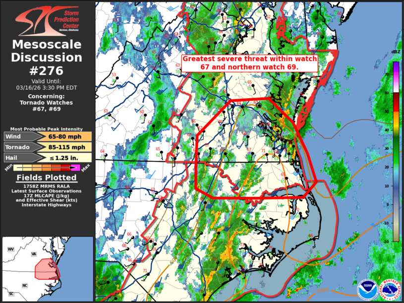
Mesoscale Discussion 0276 NWS Storm Prediction Center Norman OK 0100 PM CDT Mon Mar 16 2026 Areas affected...southeast Virginia and northeast North Carolina Concerning...Tornado Watch 67...69... Valid 161800Z - 161930Z The severe weather threat for Tornado Watch 67, 69 continues. SUMMARY...The greatest severe threat within watch 67 and the northern portion of watch 69 will be across southeast Virginia and northeast North Carolina over the next few hours. DISCUSSION...Within a broader environment that has been mostly convectively overturned, a more favorable zone remains across northeast North Carolina and southeast Virginia. Temperatures are in the upper 60s to low 70s with dewpoints in the mid 60s. This yields around 500-750 J/kg MLCAPE per SPC mesoanalysis. The AKQ VWP shows around 55 knots of deep-layer shear with mid-level flow continuing to strengthen through the afternoon. With somewhat more favorable thermodynamics in this zone, a few supercells capable of damaging wind gusts and perhaps a tornado or two are possible. ..Bentley/Thompson.. 03/16/2026 ...Please see www.spc.noaa.gov for graphic product... ATTN...WFO...AKQ...MHX...RAH... LAT...LON 36507810 37007808 37607737 37637654 37217603 36687572 36207555 35937583 35927681 35927773 36087810 36507810 MOST PROBABLE PEAK TORNADO INTENSITY...85-115 MPH MOST PROBABLE PEAK WIND GUST...65-80 MPH MOST PROBABLE PEAK HAIL SIZE...UP TO 1.25 IN |
|
|
Top/All Mesoscale Discussions/Forecast Products/Home |
|
Source link