| Mesoscale Discussion 274 | |
| < Previous MD | |

|
|
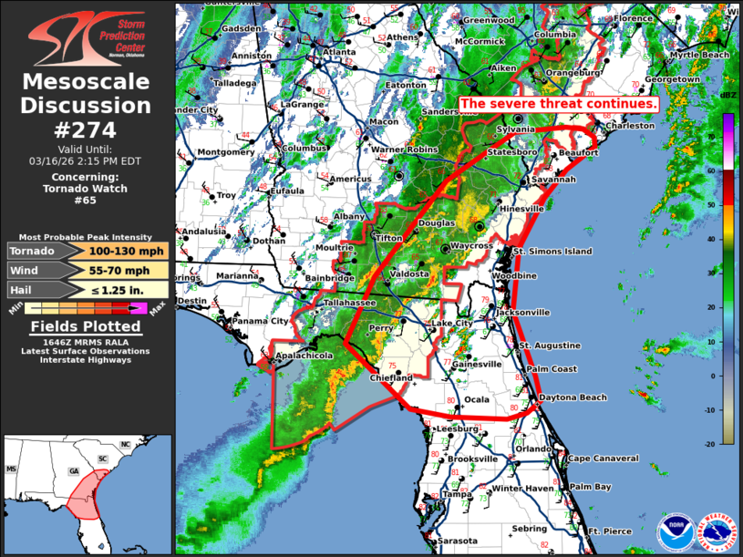
Mesoscale Discussion 0274 NWS Storm Prediction Center Norman OK 1149 AM CDT Mon Mar 16 2026 Areas affected...portions of northern Florida...southeast Georgia into coastal South Carolina. Concerning...Tornado Watch 65... Valid 161649Z - 161815Z The severe weather threat for Tornado Watch 65 continues. SUMMARY...Ongoing convection will continue eastward with severe potential. WW65 is set to expire at 18z. A local extension or a small watch downstream may be needed given the expected ongoing threat for damaging gusts and tornadoes. DISCUSSION...As of 1645 UTC, multiple bands of convection are ongoing over parts of the northern Gulf Coast from northern FL into southern GA and southern SC. A large stratiform rain shield with multiple embedded convective elements will spread eastward, effectively limiting northward expansion of a destabilizing air mass to the south. Strong kinematics in place may still support some damaging gust and brief tornado threat with embedded convection, despite weak buoyancy. However, the primary severe risk appears to be focused on stronger portions of the line over the eastern FL Panhandle, and possibly with new development over western portions of the JAX CWA. The environment remains favorable for damaging gusts and tornadoes with 1500-2000 J/kg of MLCAPE and 40-50 kt of effective shear. Given this, a local extension of WW65, or a new smaller downstream watch are being considered to cover the expected severe risk. ..Lyons/Thompson.. 03/16/2026 ...Please see www.spc.noaa.gov for graphic product... ATTN...WFO...CHS...MLB...TBW...JAX...FFC...TAE... LAT...LON 29258095 29088117 29018146 29038231 29148291 29998391 30878348 32158239 32798131 32858052 32818024 32708008 32588007 32298051 31918086 31268126 30428137 29568103 29258095 MOST PROBABLE PEAK TORNADO INTENSITY...100-130 MPH MOST PROBABLE PEAK WIND GUST...55-70 MPH MOST PROBABLE PEAK HAIL SIZE...UP TO 1.25 IN |
|
|
Top/All Mesoscale Discussions/Forecast Products/Home |
|
Source link