| Mesoscale Discussion 271 | |
| < Previous MD | |
|
|
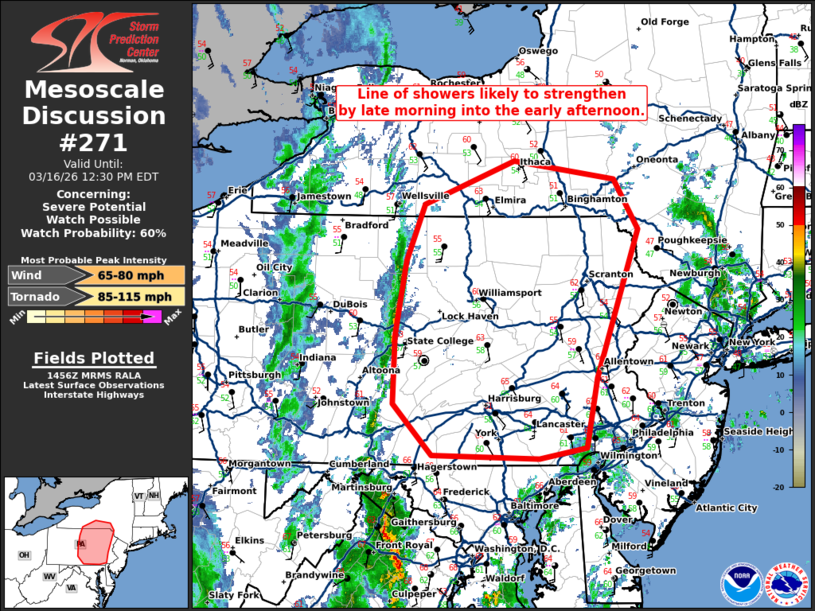
   Mesoscale Discussion 0271
   NWS Storm Prediction Center Norman OK
   0957 AM CDT Mon Mar 16 2026

   Areas affected...central Pennsylvania into far southern New York

   Concerning...Severe potential...Watch possible

   Valid 161457Z - 161630Z

   Probability of Watch Issuance...60 percent

   SUMMARY...A line of showers is likely to strengthen by late morning
   into the early afternoon.

   DISCUSSION...A line of showers has developed along a pre-frontal
   trough across central Pennsylvania this morning. Based on SPC
   mesoanalysis, it is currently in a very weakly unstable environment.
   However, as it moves farther east, temperatures are warmer (mid 60s
   F) with some low 60s dewpoints. As temperatures cool aloft, this
   should result in greater instability through the late morning and
   into the early afternoon.

   Additional strengthening of this line and additional storm
   development ahead of this line may result in some increase severe
   weather threat. Damaging winds and perhaps a few tornadoes (given
   the strong low-level shear), will be the primary threat.

   As the intensity of this convection increases, a tornado watch may
   be needed.

   ..Bentley/Thompson.. 03/16/2026

   ...Please see www.spc.noaa.gov for graphic product...

   ATTN...WFO...PHI...BGM...CTP...

   LAT...LON   40517554 39877567 39777623 39807753 40277800 40907797
               41597785 42117762 42507654 42347532 41877503 40517554

   MOST PROBABLE PEAK TORNADO INTENSITY...85-115 MPH
   MOST PROBABLE PEAK WIND GUST...65-80 MPH
|
|
|
Top/All Mesoscale Discussions/Forecast Products/Home |
|
Source link