| Mesoscale Discussion 268 | |
| < Previous MD | |

|
|
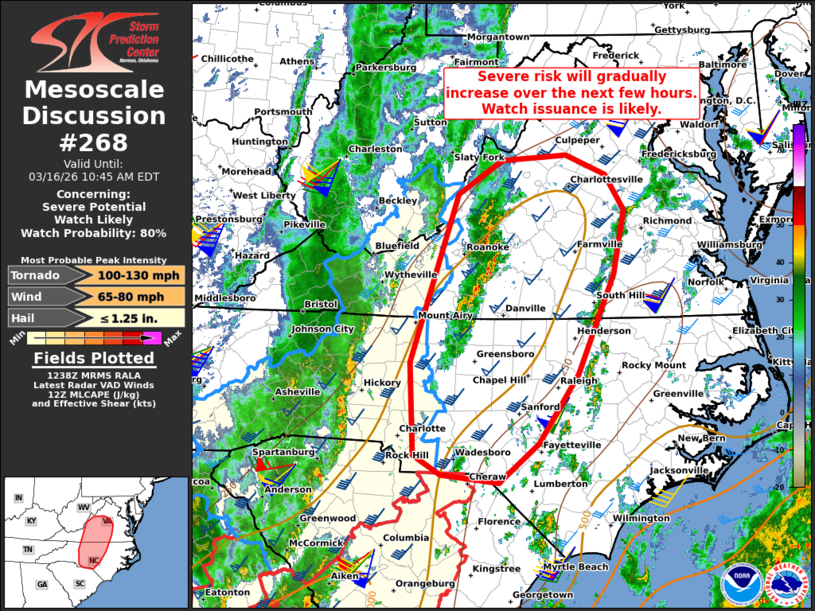
   Mesoscale Discussion 0268
   NWS Storm Prediction Center Norman OK
   0740 AM CDT Mon Mar 16 2026

   Areas affected...Parts of central Virginia into central North
   Carolina

   Concerning...Severe potential...Watch likely

   Valid 161240Z - 161445Z

   Probability of Watch Issuance...80 percent

   SUMMARY...The potential for damaging wind gusts and tornadoes will
   gradually increase into parts of central North Carolina and Virginia
   through the morning into this afternoon. A watch issuance is likely.

   DISCUSSION...A remnant QLCS is emerging east of the Appalachians,
   where it is showing some early signs of re-intensification. Farther
   east, a disorganized band of thunderstorms is also evolving over
   parts of western VA into NC. While overall convective evolution is
   not clear, these storms will continue spreading eastward into a
   destabilizing air mass (around 500-1000 J/kg MLCAPE). Despite the
   somewhat limited buoyancy, strong low/deep-layer shear characterized
   by clockwise-curved low-level hodographs (see GSO 12Z sounding) will
   favor a mix of organized line segments and supercells, with a risk
   of damaging wind gusts and a few tornadoes (some potentially
   strong). A watch issuance is likely for this activity.

   ..Weinman/Hart.. 03/16/2026

   ...Please see www.spc.noaa.gov for graphic product...

   ATTN...WFO...AKQ...LWX...RAH...ILM...RNK...CAE...GSP...

   LAT...LON   35018062 36058067 37938001 38327941 38387851 38157795
               37767769 37037785 35917834 35137889 34707944 34798025
               35018062

   MOST PROBABLE PEAK TORNADO INTENSITY...100-130 MPH
   MOST PROBABLE PEAK WIND GUST...65-80 MPH
   MOST PROBABLE PEAK HAIL SIZE...UP TO 1.25 IN
|
|
|
Top/All Mesoscale Discussions/Forecast Products/Home |
|
Source link