| Mesoscale Discussion 265 | |
| < Previous MD | |

|
|
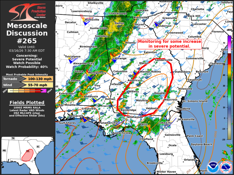
   Mesoscale Discussion 0265
   NWS Storm Prediction Center Norman OK
   0501 AM CDT Mon Mar 16 2026

   Areas affected...Parts of southern/central GA into far northern FL

   Concerning...Severe potential...Watch possible

   Valid 161001Z - 161130Z

   Probability of Watch Issuance...40 percent

   SUMMARY...Monitoring for some increase in severe-storm potential.

   DISCUSSION...Along and east of a 40-50 kt southerly low-level jet
   (per VWP) extending across parts of GA into SC, broad/weak positive
   theta-e advection amid middle/upper 60s boundary-layer dewpoints and
   limited inhibition is yielding widely scattered thunderstorm
   development. While most of these updrafts have been shallow, a
   couple isolated storms in south-central GA have shown signs of
   organization and pose a risk of a tornado and locally damaging gusts
   in the near term. Given low-level clockwise hodograph curvature and
   the rich boundary-layer moisture, there is some potential for
   additional intensification within this corridor. However, the
   weak/unfocused forcing for ascent limits confidence in this
   scenario, and the need for a watch is uncertain (though trends are
   being monitored).

   ..Weinman/Hart.. 03/16/2026

   ...Please see www.spc.noaa.gov for graphic product...

   ATTN...WFO...CHS...CAE...JAX...FFC...TAE...

   LAT...LON   30878470 31278470 32718350 33118281 33108227 32878194
               32278184 31548216 31208235 30718284 30498367 30608436
               30878470

   MOST PROBABLE PEAK TORNADO INTENSITY...100-130 MPH
   MOST PROBABLE PEAK WIND GUST...55-70 MPH
|
|
|
Top/All Mesoscale Discussions/Forecast Products/Home |
|
Source link