| Mesoscale Discussion 263 | |
| < Previous MD Next MD > | |
|
|
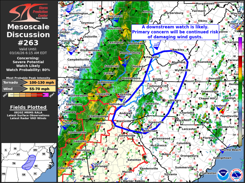
   Mesoscale Discussion 0263
   NWS Storm Prediction Center Norman OK
   0321 AM CDT Mon Mar 16 2026

   Areas affected...Far southern WV...western VA...far eastern
   TN...western NC and SC

   Concerning...Severe potential...Watch likely

   Valid 160821Z - 161015Z

   Probability of Watch Issuance...80 percent

   SUMMARY...The risk of damaging winds will continue with an
   eastward-advancing squall line. A downstream watch is likely.

   DISCUSSION...A north/south-oriented QLCS is tracking eastward across
   eastern KY, TN, and northern GA at around 40 kt. While
   boundary-layer moisture and surface-based buoyancy is limited ahead
   of the line (especially with northward extent), very strong
   deep-layer flow/shear oriented parallel to the leading gust front
   should continue to support the maintenance of the QLCS with eastward
   extent. Given the linear mode, damaging wind gusts will continue to
   be the primary concern, though an embedded mesovortex tornado cannot
   be entirely ruled out -- given strong low-level shear. A downstream
   watch will likely be issued soon.

   ..Weinman/Hart.. 03/16/2026

   ...Please see www.spc.noaa.gov for graphic product...

   ATTN...WFO...RNK...RLX...GSP...MRX...JKL...FFC...

   LAT...LON   37368226 37658211 37808159 37818110 37658062 37348038
               36868049 36188085 35288138 34708199 34478252 34608331
               34768396 34988411 35378396 35878329 36568263 37368226

   MOST PROBABLE PEAK TORNADO INTENSITY...100-130 MPH
   MOST PROBABLE PEAK WIND GUST...55-70 MPH
|
|
|
Top/All Mesoscale Discussions/Forecast Products/Home |
|
Source link