| Mesoscale Discussion 262 | |
| < Previous MD | |
|
|
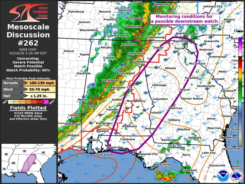
   Mesoscale Discussion 0262
   NWS Storm Prediction Center Norman OK
   0237 AM CDT Mon Mar 16 2026

   Areas affected...Far western NC/SC...northern/western GA...southeast
   AL...and western FL Panhandle

   Concerning...Severe potential...Watch possible

   Valid 160737Z - 160930Z

   Probability of Watch Issuance...60 percent

   SUMMARY...Monitoring environmental and convective trends for a
   possible downstream watch. The primary concern would be damaging
   wind gusts.

   DISCUSSION...The latest mosaic radar data depicts a
   northeast/southwest-oriented QLCS advancing eastward across eastern
   TN, far northwest GA, and northern/central AL -- with additional
   isolated thunderstorms attempting to intensify ahead of the line in
   AL. This activity continues to pose a risk of damaging gusts and a
   couple tornadoes. Downstream, the pre-convective environment is
   characterized by weak to moderate surface-based buoyancy (higher
   with southward extent) and around 50 kt of line-parallel 0-6 km
   shear (per regional VWP). This, along with a 40-50 kt low-level jet,
   should continue to support the maintenance of the QLCS with eastward
   extent. Despite some uncertainty in the severe risk with eastward
   and northward extent, the potential for damaging gusts and perhaps
   an embedded tornado or two may continue, and a new downstream watch
   may be needed.

   ..Weinman/Hart.. 03/16/2026

   ...Please see www.spc.noaa.gov for graphic product...

   ATTN...WFO...GSP...MRX...FFC...TAE...BMX...MOB...

   LAT...LON   30678713 32798629 34798451 35138393 35098325 34828279
               34448267 33918281 33018340 31068497 30458564 30258644
               30328696 30678713

   MOST PROBABLE PEAK TORNADO INTENSITY...100-130 MPH
   MOST PROBABLE PEAK WIND GUST...55-70 MPH
   MOST PROBABLE PEAK HAIL SIZE...UP TO 1.25 IN
|
|
|
Top/All Mesoscale Discussions/Forecast Products/Home |
|
Source link