| Mesoscale Discussion 260 | |
| < Previous MD | |

|
|
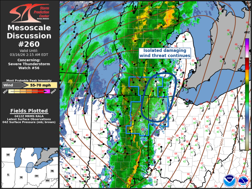
Mesoscale Discussion 0260 NWS Storm Prediction Center Norman OK 1114 PM CDT Sun Mar 15 2026 Areas affected...Southeast Lower Michigan...northeast Indiana...northwest Ohio Concerning...Severe Thunderstorm Watch 56... Valid 160414Z - 160615Z The severe weather threat for Severe Thunderstorm Watch 56 continues. SUMMARY...Isolated damaging wind risk continues with progressive squall line. However, a new watch is not currently anticipated. DISCUSSION...Strongly forced band of pre-frontal convection is propagating northeast across northeast IN/southern Lower MI and extreme northwest OH. Boundary layer air mass has gradually recovered into southeast MI over the last few hours which is contributing to weak buoyancy, immediately ahead of this convection. However, updrafts appear to be weakening a bit as lighting with the northern portions of the squall line is decreasing, and the linear nature of this activity is becoming more diffuse with time. Given the current trends a new watch is not currently anticipated. ..Darrow.. 03/16/2026 ...Please see www.spc.noaa.gov for graphic product... ATTN...WFO...CLE...DTX...IWX...GRR... LAT...LON 41108512 42398467 42398349 40918403 41108512 MOST PROBABLE PEAK WIND GUST...55-70 MPH |
|
|
Top/All Mesoscale Discussions/Forecast Products/Home |
|
Source link