| Mesoscale Discussion 259 | |
| < Previous MD Next MD > | |
|
|
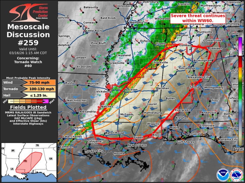
Mesoscale Discussion 0259 NWS Storm Prediction Center Norman OK 1114 PM CDT Sun Mar 15 2026 Areas affected...far northeastern Louisiana...southern Mississippi...and northern/central Alabama Concerning...Tornado Watch 60... Valid 160414Z - 160615Z The severe weather threat for Tornado Watch 60 continues. SUMMARY...Severe threat continues within WW60. DISCUSSION...A line of thunderstorms continues eastward across the Gulf States this evening, producing occasional reports of damaging wind and small hail. Ahead of this line across southern Mississippi into central/northern Alabama, a favorable unstable and strongly sheared air mass remains in place with MLCAPE around 1000-1500 J/kg and deep layer shear around 40 kts. This will be sufficient to allow for more organized line embedded mesovorticies that may produce damaging wind and tornadoes over the next few hours. Southward across southern MS/southern AL near the coast, occasional isolated showers and thunderstorms have been noted. Should a more discrete storm be able to get going within the open warm sector ahead of the main squall line, this may pose a somewhat greater risk for a tornado given more favorable moisture profiles with dew points in the upper 60s to 70s. ..Thornton.. 03/16/2026 ...Please see www.spc.noaa.gov for graphic product... ATTN...WFO...BMX...HUN...MOB...MEG...JAN...LIX... LAT...LON 30969178 32898975 34058833 34308745 34128615 33908590 32868636 30508884 30338953 30299087 30419154 30439163 30969178 MOST PROBABLE PEAK TORNADO INTENSITY...100-130 MPH MOST PROBABLE PEAK WIND GUST...75-90 MPH MOST PROBABLE PEAK HAIL SIZE...UP TO 1.25 IN |
|
|
Top/All Mesoscale Discussions/Forecast Products/Home |
|
Source link