| Mesoscale Discussion 257 | |
| < Previous MD | |
|
|
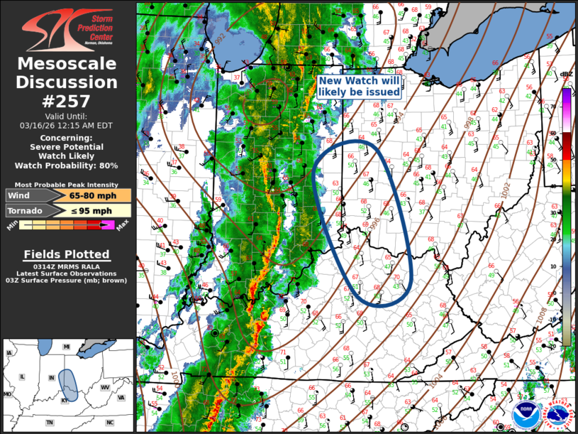
Mesoscale Discussion 0257 NWS Storm Prediction Center Norman OK 1015 PM CDT Sun Mar 15 2026 Areas affected...Eastern Indiana...western Ohio...northern Kentucky Concerning...Severe potential...Watch likely Valid 160315Z - 160415Z Probability of Watch Issuance...80 percent SUMMARY...New watch will likely be issued from eastern Indiana/western Ohio into northern Kentucky. DISCUSSION...Strongly forced QLCS is advancing steadily east across IN/western KY in response to a progressive short-wave trough that is approaching this region. Boundary-layer moisture is a bit scant downstream of this squall line with surface dew points struggling to rise through the upper 40s to near 50F. Additionally, forecast soundings suggest a warm layer near 3km is likely suppressing pre-frontal convection well ahead of the squall line. With time, cooling/moistening profiles will remove this warm layer and weak buoyancy will develop just prior to the frontal passage. This should prove adequate for the maintenance and eastward propagation of this linear MCS. While a tornado or two can not be ruled out due to very strong shear, storm mode and weak buoyancy suggest damaging winds are the primary concern. ..Darrow/Smith.. 03/16/2026 ...Please see www.spc.noaa.gov for graphic product... ATTN...WFO...JKL...ILN...LMK...IND... LAT...LON 37998449 40028541 40408409 38238336 37998449 MOST PROBABLE PEAK TORNADO INTENSITY...UP TO 95 MPH MOST PROBABLE PEAK WIND GUST...65-80 MPH |
|
|
Top/All Mesoscale Discussions/Forecast Products/Home |
|
Source link