| Mesoscale Discussion 254 | |
| < Previous MD Next MD > | |
|
|
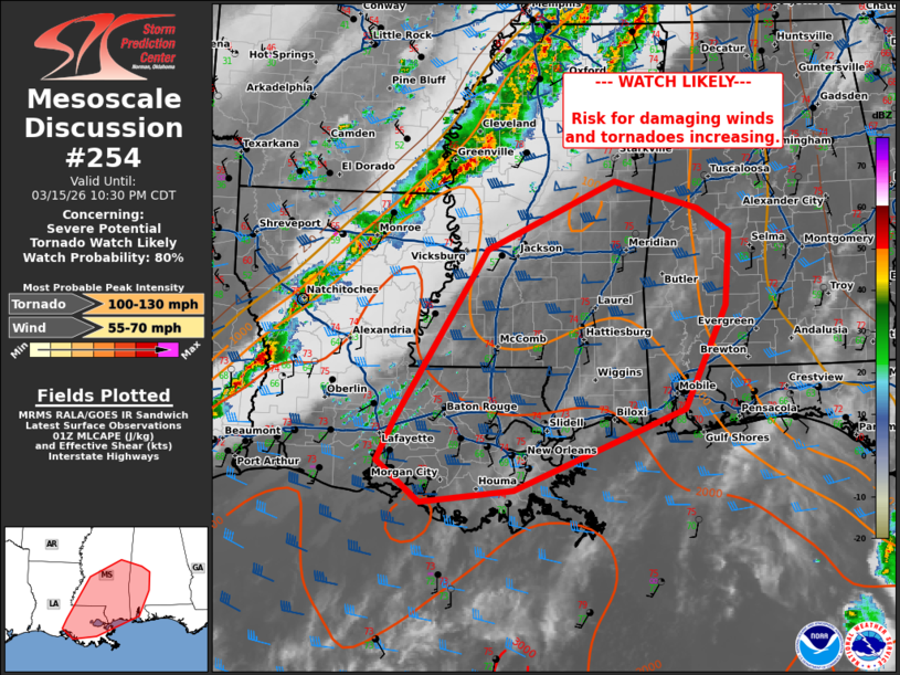
   Mesoscale Discussion 0254
   NWS Storm Prediction Center Norman OK
   0828 PM CDT Sun Mar 15 2026

   Areas affected...southeast Louisiana...southern Mississippi...and
   southwestern into west-central Alabama

   Concerning...Severe potential...Tornado Watch likely

   Valid 160128Z - 160330Z

   Probability of Watch Issuance...80 percent

   SUMMARY...Damaging wind and tornado risk to increase this evening.

   DISCUSSION...A broken line of thunderstorms continues near a cold
   front sagging southward and east across central LA into southeast
   Texas. Further east ahead of the front, attempts at development are
   starting to occur across southern Louisiana as MLCIN has begin to
   erode over the last hour. It is likely that ongoing convection will
   move downstream, with additional development possible ahead of this
   across southern Louisiana into southern Mississippi. MLCAPE around
   1000-2000 J/kg will overlap with deep layer shear around 40 kts to
   support supercells ahead of the main line and more clustered/mixed
   mode/line embedded supercells closer to the cold front. Primary
   risks would be for damaging winds and tornadoes, though some
   instances of hail could occur with discrete supercells. A watch will
   be needed soon to cover this threat.

   ..Thornton/Smith.. 03/16/2026

   ...Please see www.spc.noaa.gov for graphic product...

   ATTN...WFO...BMX...MOB...JAN...LIX...LCH...

   LAT...LON   30379183 32369059 33158885 32848772 32578730 31708735
               30518792 29579021 29439148 29909206 30379183

   MOST PROBABLE PEAK TORNADO INTENSITY...100-130 MPH
   MOST PROBABLE PEAK WIND GUST...55-70 MPH
|
|
|
Top/All Mesoscale Discussions/Forecast Products/Home |
|
Source link