| Mesoscale Discussion 245 | |
| < Previous MD | |

|
|
Mesoscale Discussion 0245
NWS Storm Prediction Center Norman OK
0118 PM CDT Sun Mar 15 2026
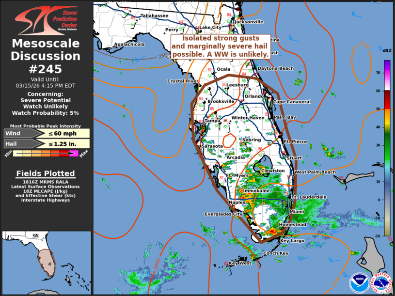
Areas affected...Southern and central Florida
Concerning...Severe potential...Watch unlikely
Valid 151818Z - 152015Z
Probability of Watch Issuance...5 percent
SUMMARY...Scattered to numerous thunderstorms may pose an isolated
severe risk for occasional damaging gusts and hail through the
afternoon. Organization appears limited and a WW is unlikely.
DISCUSSION...As of 1915 UTC, regional radar analysis showed
scattered to numerous thunderstorms had developed across portions of
southern FL, with additional storms developing along the typical sea
breeze boundaries. Strong heating amid seasonably rich low-level
moisture (dewpoints in the 70s F) is contributing to roughly 2000
J/kg of MLCAPE. However, flow aloft is rather modest, with
deep-layer shear on area VADs generally below 25 kt. Thus far, storm
organization potential appears limited with a multicell mode. Still,
transient stronger updrafts are possible given the degree of
buoyancy. This, along with some clustering has been noted in radar
trends, suggesting some stronger downdrafts and isolated damaging
gust potential. While isolated damaging gusts or marginally severe
hail are possible, the limited storm organization suggests the
severe threat will remain localized. A WW is unlikely this
afternoon.
..Lyons/Gleason.. 03/15/2026
...Please see www.spc.noaa.gov for graphic product...
ATTN...WFO...MFL...MLB...TBW...JAX...
LAT...LON 25128090 26358208 27538272 28428278 28888243 29138178
29048102 28678044 27798021 27097996 26078001 25648014
25358036 25128090
MOST PROBABLE PEAK WIND GUST...UP TO 60 MPH
MOST PROBABLE PEAK HAIL SIZE...UP TO 1.25 IN
|
|
|
Top/All Mesoscale Discussions/Forecast Products/Home |
|
Source link