| Mesoscale Discussion 244 | |
| < Previous MD | |

|
|
Mesoscale Discussion 0244
NWS Storm Prediction Center Norman OK
1231 PM CDT Sun Mar 15 2026
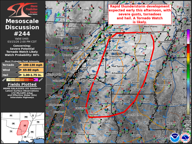
Areas affected...Arkansas...eastern Oklahoma...northeast Texas and
northwestern Louisiana.
Concerning...Severe potential...Tornado Watch likely
Valid 151731Z - 151900Z
Probability of Watch Issuance...80 percent
SUMMARY...Rapid severe thunderstorm development is expected early
this afternoon from eastern OK into AR, northeast TX into northern
LA. All hazards are possible with an eventual QLCS.
DISCUSSION...As of 1730 UTC, regional satellite imagery showed
initial ascent ahead of a potent shortwave trough was impinging upon
the intersection of a cold front and weak dryline over parts of
eastern OK and far southwest MO. Exceptionally strong mid-level
ascent (8-10 cm/s observed from the SGF soundings) will overspread a
rapidly warming/moistening air mass resulting in destabilization
this afternoon.
Rapid thunderstorm initiation is expected in the next couple of
hours as ascent continues and the front impinges upon the plume of
returning surface moisture. While modest, surface dewpoints in the
low to mid 60s F amid steep mid-level lapse rates will support
1000-2000 J/kg of MUCAPE. 50+ kt of deep-layer shear will favor
storm organization with a mixed mode of supercells and line
segments. The surging nature of the front suggests rapid upscale
growth into a QLCS is also likely this afternoon before spreading
eastward. Strong low and mid-level shear (ESRH 200-300 m2/s2) may
still support embedded supercellular elements, along with QLCS
circulations. Enhanced lower tropospheric flow of 30-50 kt is
favorable for damaging gusts and embedded tornadoes. Hail is less
certain, but will likely remain tied to more isolated initial
semi-cellular development into parts of southwest AR and northwest
LA/northeast TX.
Observational trends and the latest CAM guidance show thunderstorms
developing first along the most progressive portions of the cold
front from far southern MO into far eastern OK and western AR.
Additional development farther southwest may be somewhat more
gradual as large-scale forcing for ascent is weaker and residual
capping is likely to remain in place. With time, widespread
thunderstorms should mature within a favorable CAPE/shear space,
increasing the severe risk. Given this, one or more Tornado Watches
are likely this afternoon.
..Lyons/Gleason.. 03/15/2026
...Please see www.spc.noaa.gov for graphic product...
ATTN...WFO...LZK...SHV...TSA...FWD...
LAT...LON 36439134 36009113 35609113 34289159 33649186 32629249
32009320 31759418 31699550 32209573 32979555 34209502
36079426 36459372 36499230 36439134
MOST PROBABLE PEAK TORNADO INTENSITY...100-130 MPH
MOST PROBABLE PEAK WIND GUST...65-80 MPH
MOST PROBABLE PEAK HAIL SIZE...1.00-1.75 IN
|
|
|
Top/All Mesoscale Discussions/Forecast Products/Home |
|
Source link