| Mesoscale Discussion 241 | |
| < Previous MD | |
|
|
Mesoscale Discussion 0241
NWS Storm Prediction Center Norman OK
0540 AM CDT Sun Mar 15 2026
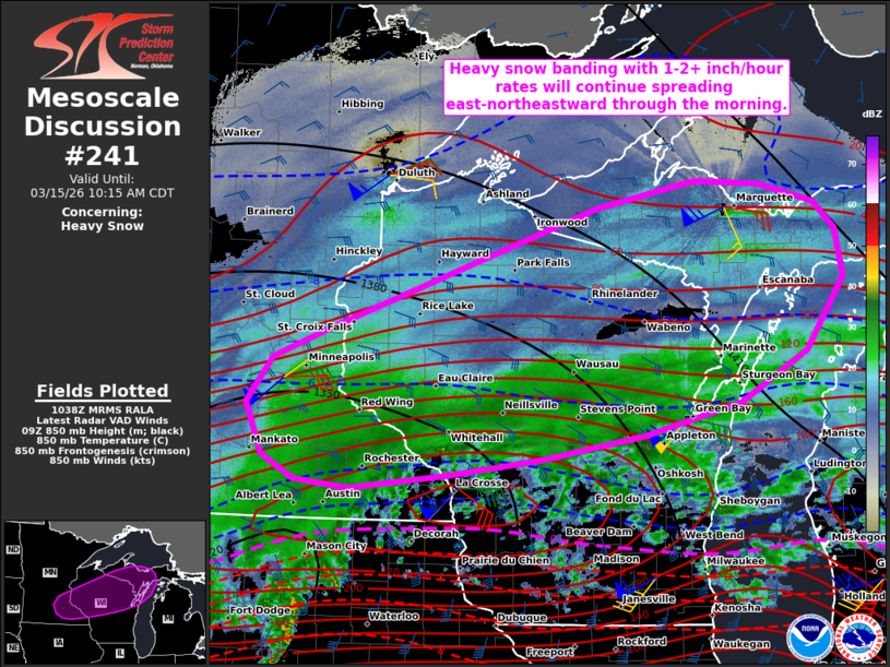
Areas affected...Southeast MN...central/northern WI...and parts of
Upper MI
Concerning...Heavy snow
Valid 151040Z - 151515Z
SUMMARY...Banded heavy snow with 1-2+ inch per hour rates will
continue spreading east-northeastward through the morning hours.
DISCUSSION...The latest mosaic radar data and surface observations
indicate banded heavy snow extending across parts of southern MN
into central WI, with the most intense portion of the band currently
focused over parts of southeastern MN. Over the next several hours,
the deep frontogenetic circulation and related mesoscale ascent that
is supporting these heavy snowfall rates will continue spreading
east-northeastward from southeastern MN across central/northern WI
and eventually into Upper MI. Given the strong/focused lift and
cold/deeply saturated profiles, an expansive area of 1 inch per hour
snowfall rates can be expected. Beneath the core of the more
organized banding, rates could exceed 2 inches per hour. Along the
southern fringes of the heavy snow, a substantial warm nose and
steep midlevel lapse rates/weak instability will continue to support
convective elements with mixed winter precipitation (freezing rain
and sleet) and widely scattered lightning flashes.
..Weinman.. 03/15/2026
...Please see www.spc.noaa.gov for graphic product...
ATTN...WFO...MQT...GRB...DLH...ARX...MPX...
LAT...LON 43809266 43879340 44109384 44619405 45059370 45339295
46528927 46778794 46738705 46558630 46298601 45828591
45128644 44648734 44328864 44109003 43939132 43809266
|
|
|
Top/All Mesoscale Discussions/Forecast Products/Home |
|
Source link