| Mesoscale Discussion 234 | |
| < Previous MD | |

|
|
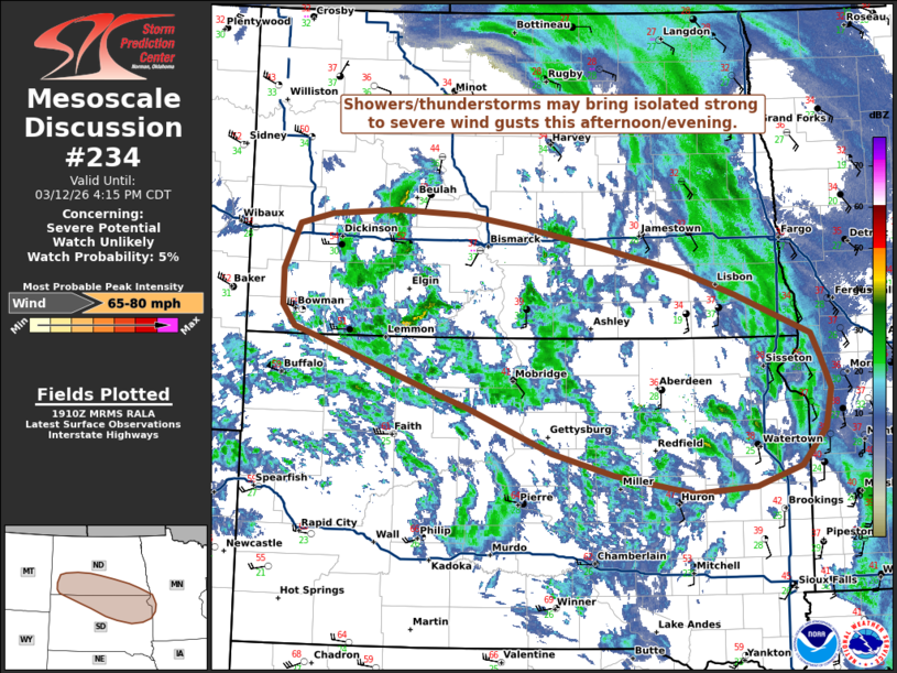
   Mesoscale Discussion 0234
   NWS Storm Prediction Center Norman OK
   0213 PM CDT Thu Mar 12 2026

   Areas affected...portions of southern North Dakota and northern
   South Dakota into extreme western Minnesota

   Concerning...Severe potential...Watch unlikely

   Valid 121913Z - 122115Z

   Probability of Watch Issuance...5 percent

   SUMMARY...Showers/thunderstorms may bring isolated strong to severe
   wind gusts to portions of the Dakotas and extreme western Minnesota
   this afternoon. Watch issuance is not anticipated.

   DISCUSSION...Latest RAP-based mesoanalysis and forecast soundings
   depict the development of very weak buoyancy across portions of the
   northern Great Plains this afternoon amidst steep low-level lapse
   rates. Confidence in this scenario remains low given very limited
   buoyancy and low-level moisture (surface dewpoints in the mid-20s
   F). Isolated lightning flashes have been noted over the past 30-60
   minutes, however, indicating the development of a couple marginally
   deeper cores. This shallow convection may augment very strong
   northwesterly low-to-mid level flow (40-50+ kt at 1-2 km AGL per
   regional VWPs), supporting the potential for isolated strong to
   severe wind gusts.

   ..Chalmers/Gleason.. 03/12/2026

   ...Please see www.spc.noaa.gov for graphic product...

   ATTN...WFO...MPX...FGF...FSD...ABR...BIS...UNR...

   LAT...LON   46010338 46210355 46560356 46980335 47080291 47130202
               47100106 46980030 46809925 46569812 46339742 45959639
               45739627 45439613 45069622 44719654 44519716 44469798
               44639906 44849990 45260102 45470168 45800267 46010338

   MOST PROBABLE PEAK WIND GUST...65-80 MPH
|
|
|
Top/All Mesoscale Discussions/Forecast Products/Home |
|
Source link