|
|
| Mesoscale Discussion 2306 | |
| < Previous MD Next MD > | |

|
|
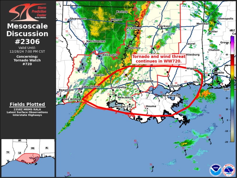
Mesoscale Discussion 2306 NWS Storm Prediction Center Norman OK 0600 PM CST Sat Dec 28 2024 Areas affected...southern Louisiana and far southern Mississippi Concerning...Tornado Watch 720... Valid 290000Z - 290100Z The severe weather threat for Tornado Watch 720 continues. SUMMARY...Threat for tornadoes and wind to continue across southern Louisiana into far southern Mississippi. DISCUSSION...A line of thunderstorms with embedded supercells structures continues across portions of southern Louisiana into Mississippi as of 00z. The environment across this region remains highly favorable, with MLCAPE around 2000-2500 J/kg amid surface dew points in the upper 60s to 70s. Forcing for ascent has begun to gradually shift northward but strongly sheared profiles remain favorable for supercell maintenance. VAD profiles from HDC (Hammond, LA) show favorable curvature in the bottom 0-3 km, with 0-500m SRH around 300 m2/s2. This in combination with favorable thermodynamics will continue to support a risk for tornadoes, some of which may be strong. Potential for damaging winds will also remain likely with more linear storm modes. Local extension of WW720 has occurred across southeastern LA into southern MS to cover this threat. ..Thornton/Gleason.. 12/29/2024 ...Please see www.spc.noaa.gov for graphic product... ATTN...WFO...MOB...JAN...LIX...LCH... LAT...LON 29869314 30279264 30629219 30849184 31019133 31019046 31028996 30988938 30878872 30718850 30498850 30298855 29948873 29648904 29348968 29329038 29439150 29619255 29869314 |
|
|
Top/All Mesoscale Discussions/Forecast Products/Home |
|


