|
|
| Mesoscale Discussion 2303 | |
| < Previous MD | |

|
|
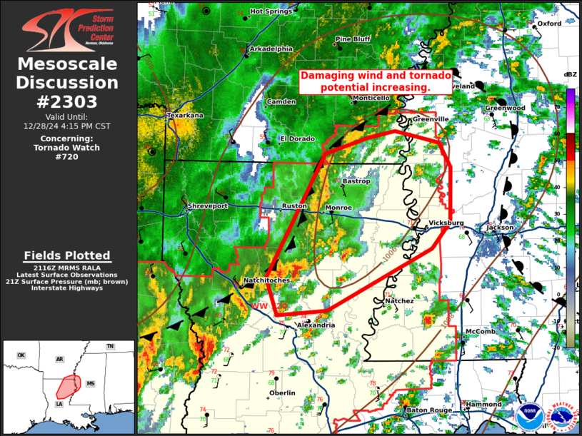
Mesoscale Discussion 2303 NWS Storm Prediction Center Norman OK 0317 PM CST Sat Dec 28 2024 Areas affected...portions of northeastern LA and far western MS Concerning...Tornado Watch 720... Valid 282117Z - 282215Z The severe weather threat for Tornado Watch 720 continues. SUMMARY...A maturing QLCS with a prominent bowing segment and several small supercells may pose an increasing threat for tornadoes and damaging gusts over the next couple of hours. DISCUSSION...As of 2110 UTC, local radar imagery showed a maturing QLCS across north-central LA. Within this intensifying line, a bowing segment/hybrid supercell structure has recently emerged over Natchitoches Parish. As upper-level forcing continuances to intensify with the approach of the upper-level trough, low-level wind fields have increased on area VADs. This is also evident in SPC mesoanalysis where a meso low has developed across southeastern AR with 2-3 mb/hr surface pressure falls. The QLCS should continue eastward into an unstable and strongly sheared air mass with 1000-1500 J/kg of MLCAPE and 300-400 m2/s2 of ESRH. The environmental trends, along with a recent report of a 72 mph wind gust, suggest damaging wind and QLCS tornado potential is increasing. Additionally, several small supercells east of the QLCS have developed stronger low-level mesocyclones over the last hour. As low-level shear intensifies, or storms interact with the surging line, the threat for tornadoes (including some strong) is expected to increase within this corridor from northeastern LA into far western MS. ..Lyons.. 12/28/2024 ...Please see www.spc.noaa.gov for graphic product... ATTN...WFO...JAN...SHV... LAT...LON 33349126 33229073 32979058 32409060 32139082 31519206 31469267 31849279 33109209 33279158 33349126 |
|
|
Top/All Mesoscale Discussions/Forecast Products/Home |
|


