|
|
| Mesoscale Discussion 2300 | |
| < Previous MD | |

|
|
   Mesoscale Discussion 2300
   NWS Storm Prediction Center Norman OK
   1115 AM CST Sat Dec 28 2024

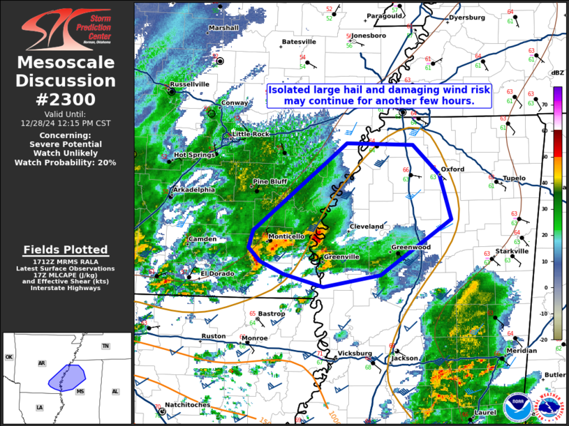
   Areas affected...portions of eastern AR and northwestern MS

   Concerning...Severe potential...Watch unlikely

   Valid 281715Z - 281815Z

   Probability of Watch Issuance...20 percent

   SUMMARY...An isolated risk for large (some 2+ in) hail and damaging
   gusts may persist for a few hours this morning and early this
   afternoon. A more substantial severe threat is expected later today.

   DISCUSSION...As of 1710 UTC, regional radar analysis showed a
   cluster of strong to severe storms (including a more dominant
   supercell) ongoing across parts of far eastern AR. Likely elevated
   above the surface north of a well-defined baroclinic zone, these
   storms have produced a few reports of large hail over the past 2
   hours. Keeping with general storm motion to the east/northeast at
   30-35 kt, these storms should cross the MS river into northwestern
   MS in the next hour. The air mass here is weakly unstable (MLCAPE
   ~500 J/kg), but also strongly sheared, which should continue to
   support at least an isolated risk for severe hail and some damaging
   gust potential for a few more hours.

   A more substantial severe risk is expected to evolve later this
   afternoon as stronger forcing for ascent and linear storms approach
   from the west/southwest. Recent HRRR guidance and radar trends over
   the ArkLaTex suggests a larger QLCS/bowing line segment may approach
   and merge with this convection as the air mass across MS continues
   to destabilize. This would favor a greater severe risk, particularly
   for damaging gusts and tornadoes this afternoon/evening.

   Thus, while there remains an isolated severe risk over the next
   couple of hours, a WW is not expected until later this afternoon.

   ..Lyons/Hart.. 12/28/2024

   ...Please see www.spc.noaa.gov for graphic product...

   ATTN...WFO...MEG...JAN...LZK...

   LAT...LON   34499101 33759197 33569202 33409187 33269157 33129105
               33259030 33878936 34368952 34698987 34719073 34499101
|
|
|
Top/All Mesoscale Discussions/Forecast Products/Home |
|


