|
|
| Mesoscale Discussion 2295 | |
| < Previous MD | |

|
|
   Mesoscale Discussion 2295
   NWS Storm Prediction Center Norman OK
   0649 AM CST Sat Dec 28 2024

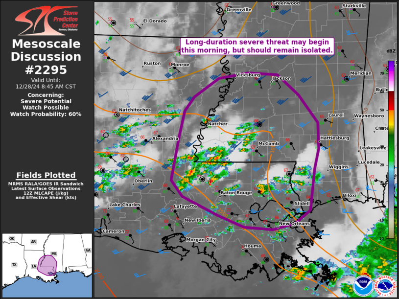
   Areas affected...eastern LA and southern MS

   Concerning...Severe potential...Watch possible

   Valid 281249Z - 281445Z

   Probability of Watch Issuance...60 percent

   SUMMARY...A long-duration severe threat may begin this morning near
   and east of the Mississippi River in Louisiana/Mississippi. This
   threat should remain lower-end and isolated for several hours before
   greater intensity/coverage occurs this afternoon. While a tornado
   watch will undoubtedly be needed later today, confidence is low on
   needing one through mid-morning.

   DISCUSSION...Scattered thunderstorms have developed across parts of
   LA into southwest MS. Regenerative development may persist for many
   hours in the southeast LA/southwest MS corridor where low-level warm
   theta-e advection continues in the wake of long-lived,
   quasistationary convection over the north-central Gulf. 12Z JAN/LCH
   observed soundings sampled relatively modest low-level hodograph
   curvature but favorable effective bulk shear for occasional updraft
   rotation. This could yield an isolated threat for all hazards this
   morning. A more prominent increase in severe potential is expected
   into the afternoon, as low-level shear increases substantially
   midday and beyond.

   ..Grams/Edwards.. 12/28/2024

   ...Please see www.spc.noaa.gov for graphic product...

   ATTN...WFO...JAN...LIX...LCH...

   LAT...LON   31409191 31829181 32059164 32359117 32439063 32409007
               32078967 31638930 31208930 30898938 30228946 30008975
               29919016 29959070 30149118 30439184 30699205 31409191
|
|
|
Top/All Mesoscale Discussions/Forecast Products/Home |
|


