|
|
| Mesoscale Discussion 2293 | |
| < Previous MD | |

|
|
   Mesoscale Discussion 2293
   NWS Storm Prediction Center Norman OK
   0446 AM CST Sat Dec 28 2024

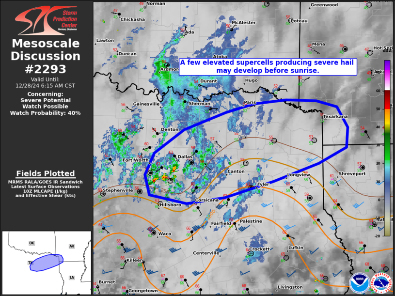
   Areas affected...north TX to the Ark-La-Tex

   Concerning...Severe potential...Watch possible

   Valid 281046Z - 281215Z

   Probability of Watch Issuance...40 percent

   SUMMARY...A few elevated supercells with a primary threat of severe
   hail may develop before sunrise. Monitoring for a possible severe
   thunderstorm watch, north of a probable tornado watch later.

   DISCUSSION...Elevated thunderstorms have commenced in/around the
   Metroplex across north TX. This activity is expected to increase in
   coverage through mid-morning along a pronounced north/south-oriented
   gradient in buoyancy across east TX. With this activity occurring
   atop a stable, but shallow near-surface layer, convection will
   probably remain elevated to slightly elevated through 14-15Z. The
   FWS VWP confirms a nearly unidirectional, southwesterly wind
   profile, with the more pronounced speed shear between 3-5 km AGL.
   With some strengthening of mid-level winds expected this morning,
   this setup should foster potential for a few elevated supercells
   capable of producing large hail to around golf-ball size.

   ..Grams/Edwards.. 12/28/2024

   ...Please see www.spc.noaa.gov for graphic product...

   ATTN...WFO...SHV...FWD...

   LAT...LON   32539740 32889722 33269666 33559588 33699534 33749473
               33739438 33729414 33629376 33309355 32979359 32729412
               32449496 32199588 32089660 32219730 32539740
|
|
|
Top/All Mesoscale Discussions/Forecast Products/Home |
|


