| Mesoscale Discussion 2287 | |
| < Previous MD | |
|
|
Mesoscale Discussion 2287
NWS Storm Prediction Center Norman OK
0214 PM CST Mon Dec 29 2025
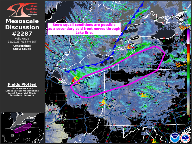
Areas affected...Northeast Ohio...northwest Pennsylvania...western
New York
Concerning...Snow Squall
Valid 292014Z - 300015Z
SUMMARY...Snow squall conditions are possible as a secondary cold
front moves off of Lake Erie. Moderate to briefly heavy snowfall and
strong wind gusts will lead to reduced visibility with this
activity.
DISCUSSION...A secondary cold front is moving through the Great
Lakes region as a potent upper low continues through southern
Ontario/Quebec. A coherent band structure has develop as the front
has approached Lake Erie. This band is expected to move onshore and
progress into Ohio/Pennsylvania/New York. Moderate to briefly heavy
snowfall may occur with this activity. Strong cold advection has led
to steep enough lapse rates in the boundary layer which could could
contribute to enhanced wind gust potential above what has already
been ongoing synoptically this afternoon.
..Wendt.. 12/29/2025
...Please see www.spc.noaa.gov for graphic product...
ATTN...WFO...BGM...BUF...CTP...PBZ...CLE...
LAT...LON 41298236 41718165 42188006 42687873 42967772 42917753
42647716 41967761 41427913 41068061 40868134 40878175
41068217 41298236
|
|
|
Top/All Mesoscale Discussions/Forecast Products/Home |
|
Source link