| Mesoscale Discussion 2256 | |
| < Previous MD | |
|
|
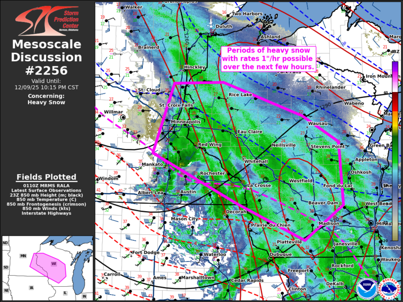
   Mesoscale Discussion 2256
   NWS Storm Prediction Center Norman OK
   0712 PM CST Tue Dec 09 2025

   Areas affected...eastern Minnesota...western/central Wisconsin

   Concerning...Heavy snow

   Valid 100112Z - 100415Z

   SUMMARY...Heavy snow to continue through the evening with occasional
   1"/hr rates.

   DISCUSSION...Heavy to moderate snow continues to be reported across
   portions of eastern MN into central WI as of 01z. The surface low
   continues to shift south and eastward, currently located over
   southern MN. 750-850 mb frontogenesis is maximized across far
   eastern MN into portions of central WI. 00z sounding from MPX shows
   a nearly saturated dendritic growth zone. Moist profiles and
   continued frontal support will continue to bring potential for heavy
   bands with 1"/hr rates over the next few hours. As the surface low
   continues to shift south and east, rates will decrease through the
   late evening/overnight.

   ..Thornton.. 12/10/2025

   ...Please see www.spc.noaa.gov for graphic product...

   ATTN...WFO...GRB...MKX...DLH...ARX...MPX...

   LAT...LON   45168976 45809185 45779315 44449368 44309332 43519148
               43189063 42818973 43488872 44668880 45168976
|
|
|
Top/All Mesoscale Discussions/Forecast Products/Home |
|
Source link