| Mesoscale Discussion 2255 | |
| < Previous MD | |

|
|
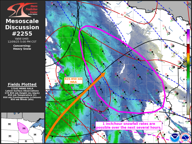
   Mesoscale Discussion 2255
   NWS Storm Prediction Center Norman OK
   1156 AM CST Tue Dec 09 2025

   Areas affected...portions of northern into central Minnesota

   Concerning...Heavy snow

   Valid 091756Z - 092300Z

   SUMMARY...Moderate to heavy snow is expected to begin over the next
   few hours. 1 inch/hour snowfall rates are possible.

   DISCUSSION...A surface-850 mb low is beginning to intensify while
   shifting southeastward across ND, which is resulting in increased
   low-level warm-air/moisture advection within a sub-freezing
   troposphere over northern to central MN. A primary band of at least
   light to moderate snow is already in place along the ND/MN border,
   and this band is expected to intensify with increased 850-700 mb
   frontogenesis over central MN over the next several hours. Increased
   saturation of the dendritic growth zone should support widespread
   moderate snowfall rates, but at least a few instances of heavy snow
   are possible, including snowfall rates locally exceeding 1
   inch/hour.

   ..Squitieri.. 12/09/2025

   ...Please see www.spc.noaa.gov for graphic product...

   ATTN...WFO...DLH...MPX...FGF...

   LAT...LON   47919705 48009693 48069675 48079663 48049635 47949602
               47629508 47199421 46929378 46239305 45759294 45389305
               45229348 45199421 45259516 45429561 45799613 47029686
               47419699 47719709 47919705
|
|
|
Top/All Mesoscale Discussions/Forecast Products/Home |
|
Source link