| Mesoscale Discussion 2254 | |
| < Previous MD | |

|
|
Mesoscale Discussion 2254
NWS Storm Prediction Center Norman OK
0902 AM CST Tue Dec 09 2025
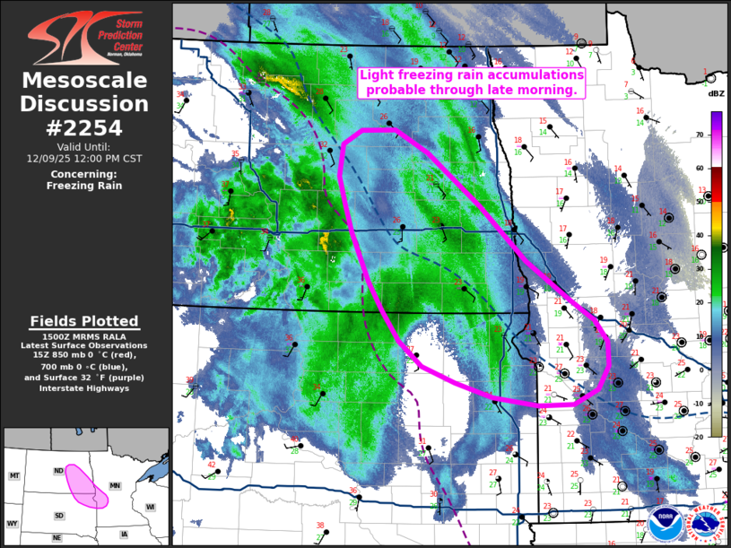
Areas affected...Southeast North Dakota into northeast South Dakota
and far western Minnesota
Concerning...Freezing rain
Valid 091502Z - 091800Z
SUMMARY...Light freezing rain accumulations appear likely over the
next few hours across southeast North Dakota into adjacent portions
of South Dakota and far western Minnesota.
DISCUSSION...Latest surface observations and 12 UTC upper air
soundings/analyses depict a zone from central ND into northeast SD
with low-level thermodynamic profiles favorable for freezing rain.
These analyses are supported by recent dual-pol imagery from KABR
which depicts a melting layer between roughly 0.5 to 1.5 km AGL. The
depth of this warm layer appears to be slightly deeper/stronger than
anticipated by morning guidance, suggesting that freezing rain may
be the preferred precipitation type over a more generic wintry mix.
Recent ASOS and mPING reports from the Jamestown, ND indicate
freezing rain is ongoing, which may become more widespread over the
next 2-3 hours as a region of stratiform precipitation spreads
east/southeast into northeast SD.
Despite a potential mid-level cool bias in recent guidance, the
general consensus is that the favorable zone for freezing rain
should constrict across western MN by late morning as low-level
warming promotes a transition to primarily rain across SD. Before
this occurs, light freezing rain accumulations appear probable.
..Moore.. 12/09/2025
...Please see www.spc.noaa.gov for graphic product...
ATTN...WFO...MPX...FGF...ABR...BIS...
LAT...LON 45839548 45599528 45319527 45039545 44869585 44869643
44959717 45129779 45319834 45609872 45959899 46299923
46859951 47169964 47499975 47869969 48039938 48049881
47789826 47169737 46539660 46079588 45839548
|
|
|
Top/All Mesoscale Discussions/Forecast Products/Home |
|
Source link