| Mesoscale Discussion 2253 | |
| < Previous MD | |
|
|
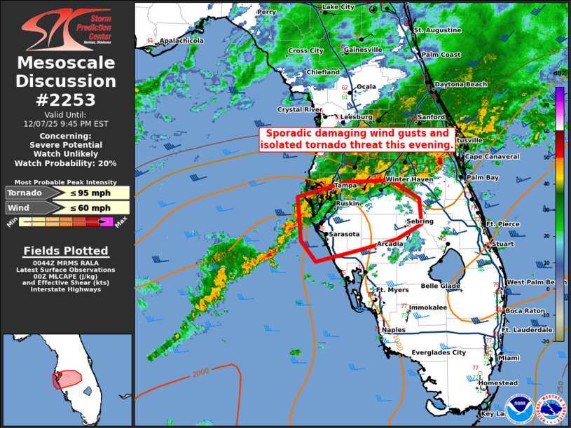
   Mesoscale Discussion 2253
   NWS Storm Prediction Center Norman OK
   0646 PM CST Sun Dec 07 2025

   Areas affected...West-central Florida

   Concerning...Severe potential...Watch unlikely

   Valid 080046Z - 080245Z

   Probability of Watch Issuance...20 percent

   SUMMARY...Sporadic damaging winds and an isolated tornado threat
   will continue this evening.

   DISCUSSION...A line of strong thunderstorms continues to approach
   the western coast of Florida this evening. Within this line, a few
   stronger supercells have developed. The KTBW WSR-88D is sampling a
   somewhat tight circulation from a supercell around 15 miles
   northwest of Anna Maria Island. Expect this storm/circulation to
   weaken as it moves into the cooler (upper 60sF) shelf-waters near
   the coast. Even if it does persist, it will likely be undercut by
   the southward moving outflow boundary within the hour which should
   end the threat. Additional storms are developing southwest of this
   circulation (farther away from the southward moving outflow) which
   may maintain some threat for the west coast of Florida through the
   evening.

   Some surface based instability is present on the 00Z TBW RAOB
   (~750-1000 J/kg MLCAPE). While weak mid-level lapse rates will
   likely inhibit new deep convection inland, enough instability may
   exist to support maintenance of the supercells that develop over the
   Gulf. These stronger storms may pose an isolated damaging
   wind/tornado threat this evening given the veered low-level wind
   profile.

   ..Bentley/Guyer.. 12/08/2025

   ...Please see www.spc.noaa.gov for graphic product...

   ATTN...WFO...MLB...TBW...

   LAT...LON   27868294 28058225 28078163 27838124 27528121 27338156
               27178218 27058268 27318289 27868294

   MOST PROBABLE PEAK TORNADO INTENSITY...UP TO 95 MPH
   MOST PROBABLE PEAK WIND GUST...UP TO 60 MPH
|
|
|
Top/All Mesoscale Discussions/Forecast Products/Home |
|
Source link