| Mesoscale Discussion 2251 | |
| < Previous MD | |

|
|
Mesoscale Discussion 2251
NWS Storm Prediction Center Norman OK
0654 PM CST Sat Dec 06 2025
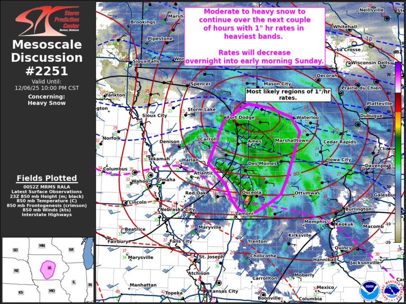
Areas affected...central Iowa
Concerning...Heavy snow
Valid 070054Z - 070400Z
SUMMARY...Moderate to heavy snow to continue across portions of
central Iowa over the next couple of hours. Occasional rates 1"/hr
with heavier bands.
DISCUSSION...Recent radar and surface observations suggest moderate
to heavy snow continues across portions of central Iowa. This is
occurring near the surface low and in the region of strong DPVA
aloft overspreading central Iowa. Two regions that will favor heavy
snow (possible 1"/hr rates) over the next couple of hours are near
the zone of 700-850 mb frontogenesis across central Iowa north of
Des Moines and in a smaller mesoscale sector along and south of I-80
and trending eastward of I-35 where a more narrow band of heavy snow
has developed. Guidance indicates a gradual downward trend in
snowfall rates is expected through the late evening/early morning
Sunday. However, periods of locally moderate snow may continue at
times across northeastern Iowa into southern Wisconsin/northern
Illinois.
..Thornton.. 12/07/2025
...Please see www.spc.noaa.gov for graphic product...
ATTN...WFO...DVN...DMX...
LAT...LON 41659462 41259415 40959400 40789385 40689358 40719337
40909298 41079272 41409255 42279223 42579245 42759301
42839358 42509421 41659462
|
|
|
Top/All Mesoscale Discussions/Forecast Products/Home |
|
Source link