| Mesoscale Discussion 2250 | |
| < Previous MD | |

|
|
Mesoscale Discussion 2250
NWS Storm Prediction Center Norman OK
1225 PM CST Sat Dec 06 2025
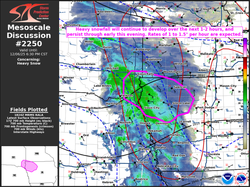
Areas affected...Far southeast South Dakota and northwestern Iowa
Concerning...Heavy snow
Valid 061825Z - 070030Z
SUMMARY...Periods of heavy snowfall are developing across portions
of far southeastern SD, and will continue to expand into
northwestern IA within an hour or two. Snowfall rates of 1 to 1.5"
per hour can be expected.
DISCUSSION...An area of moderate to heavy snow is expected to
broaden this afternoon through this evening across northwestern IA,
as a mid-level shortwave trough approaches. Increasing DPVA will
accompany this feature, in addition to strong isentropic ascent.
Most NWP models and forecast soundings suggest omega will peak
within the dendritic growth zone through ~22Z over northwestern IA.
HREF probabilities of QPF greater than 0.10" per hour, combined with
snow to liquid ratios around 15-20 to 1, also support this time
frame for the heaviest snowfall.
..Barnes.. 12/06/2025
...Please see www.spc.noaa.gov for graphic product...
ATTN...WFO...DMX...FSD...OAX...
LAT...LON 43709693 43699633 43629615 43589590 43509545 43439511
43249476 43069448 42829426 42399452 42339494 42149520
42109535 42119548 42159557 42189572 42229581 42269592
42269606 42339633 42429642 42559654 42699686 42849722
42999725 43449725 43709693
|
|
|
Top/All Mesoscale Discussions/Forecast Products/Home |
|
Source link