| Mesoscale Discussion 2245 | |
| < Previous MD | |
|
|
Mesoscale Discussion 2245
NWS Storm Prediction Center Norman OK
0159 AM CST Tue Dec 02 2025
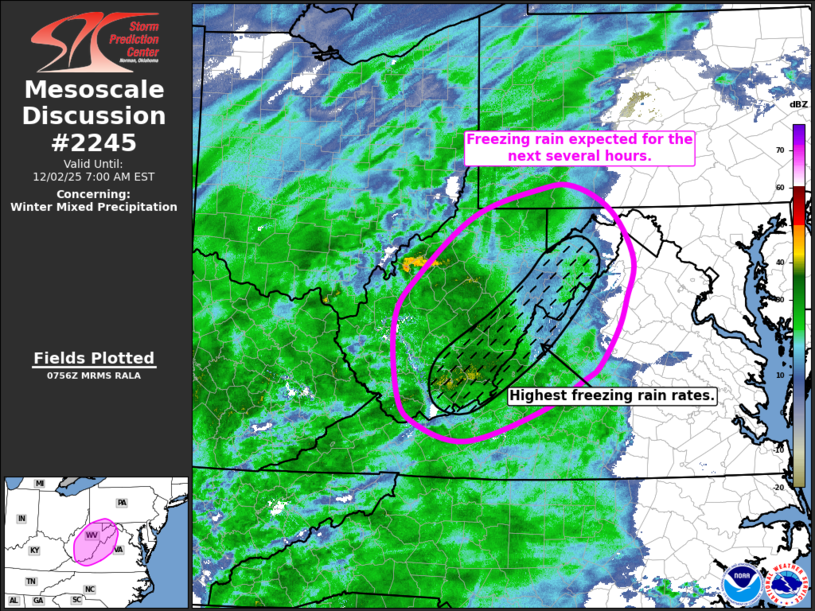
Areas affected...WV...northwestern VA...western MD...and far
southwest PA
Concerning...Winter mixed precipitation
Valid 020759Z - 021200Z
SUMMARY...Several hours of freezing rain are possible this morning
from WV into northwestern VA, western MD, and far southwest PA.
Highest freezing rain rates are expected along the Blue Ridge
Mountains.
DISCUSSION...Regional radar imagery shows a large precipitation
shield continuing to expand northeastward across WV into northwest
VA, western MD, and far southwest PA. Surface observations show
several sites in southwest WV are currently reporting freezing rain
while the sites north and east into more of eastern WV and adjacent
northwest VA and western MD are currently precipitation free.
Temperatures within the precipitation free zone are currently near
freezing, and the expectation is that temperatures will cool a
degree or two over the next free hours as the precipitation
continues to expand into the region. Recent KRLX imagery shows a
well-defined melting layer around 4 to 5 kft, suggesting that
freezing rain could be the predominant precipitation type for at
least a few hours. Some sleet could occur as well, but the
shallowness of the cold wedge should keep its occurrence isolated.
After an initial cool down with temperatures below freezing for at
least a few hours, temperatures should warm again from southwest to
northeast, with the primary precipitation type transitioning to a
rain/snow mix.
..Mosier.. 12/02/2025
...Please see www.spc.noaa.gov for graphic product...
ATTN...WFO...CTP...LWX...RNK...PBZ...RLX...
LAT...LON 38428175 38948138 39638055 39937959 39977907 39677849
39117818 38647829 38287842 37857870 37707891 37337959
36998068 37198145 37548171 38428175
|
|
|
Top/All Mesoscale Discussions/Forecast Products/Home |
|
Source link