|
|
| Mesoscale Discussion 2241 | |
| < Previous MD | |

|
|
   Mesoscale Discussion 2241
   NWS Storm Prediction Center Norman OK
   1256 PM CST Fri Nov 22 2024

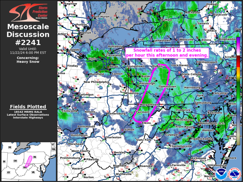
   Areas affected...the higher terrain across western
   Pennsylvania...northern West Virginia...and far western Maryland.

   Concerning...Heavy snow

   Valid 221856Z - 222300Z

   SUMMARY...Snowfall rates of 1 to 2 inches per hour this afternoon
   and evening.

   DISCUSSION...Snowfall rates have increased across the central
   Appalachians in western Pennsylvania, northern West Virginia, and
   far western Maryland as upslope flow strengthens and temperatures
   cool aloft. The strongest west-northwesterly flow (45 to 50 knots)
   will persist through 06Z before weakening. Snowfall rates of 1 to 2
   inches per hour are expected through much of this period. Some snow
   is expected at lower elevation/valley locations, but a marginal
   thermodynamic environment should limit snowfall accumulation rates
   at these lower elevations.

   In addition, some blizzard conditions are possible at the highest
   peaks where 50+ knots of winds are occurring and expected to
   continue through the overnight period.

   ..Bentley.. 11/22/2024

   ...Please see www.spc.noaa.gov for graphic product...

   ATTN...WFO...CTP...LWX...PBZ...RLX...

   LAT...LON   39727991 40497949 41007925 41257897 41227864 41047843
               40467856 39697910 39297940 39077956 39017980 39078010
               39208025 39727991
|
|
|
Top/All Mesoscale Discussions/Forecast Products/Home |
|


