| Mesoscale Discussion 224 | |
| < Previous MD Next MD > | |

|
|
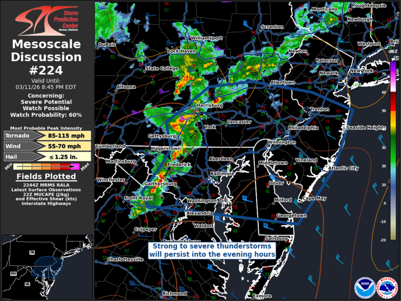
Mesoscale Discussion 0224 NWS Storm Prediction Center Norman OK 0547 PM CDT Wed Mar 11 2026 Areas affected...Northern Mid-Atlantic Concerning...Severe potential...Watch possible Valid 112247Z - 120045Z Probability of Watch Issuance...60 percent SUMMARY...Strong to severe thunderstorms are expected to persist into the early evening hours across the northern Mid Atlantic states, with damaging winds and perhaps hail being the primary threats. DISCUSSION...Strong to severe thunderstorms on the eastern edge of WW 45 will pose a threat for primarily damaging straight-line winds into the early evening hours. There is still a small window of tornado potential through at least 8 PM EDT, though forecast profiles ahead of the ongoing storms show a rapid stabilization of the nocturnal boundary layer. Even with this stabilization, there is sufficient MUCAPE and deep-layer vertical shear to support a continued severe threat as storms make the transition from surface-based to elevated. Some potential for hail exists, though is expected to largely remain at or below 1.0 inches in diameter. ..Halbert/Smith.. 03/11/2026 ...Please see www.spc.noaa.gov for graphic product... ATTN...WFO...PHI...AKQ...CTP...LWX... LAT...LON 39047785 39457751 39687732 40067743 40597662 40677582 40507468 40237392 39427427 38607497 38857773 39047785 MOST PROBABLE PEAK TORNADO INTENSITY...85-115 MPH MOST PROBABLE PEAK WIND GUST...55-70 MPH MOST PROBABLE PEAK HAIL SIZE...UP TO 1.25 IN |
|
|
Top/All Mesoscale Discussions/Forecast Products/Home |
|
Source link