| Mesoscale Discussion 2237 | |
| < Previous MD | |
|
|
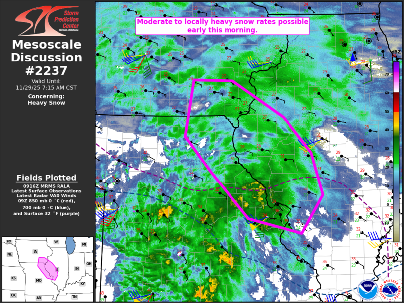
   Mesoscale Discussion 2237
   NWS Storm Prediction Center Norman OK
   0318 AM CST Sat Nov 29 2025

   Areas affected...Northeast/east-central MO...southeast IA...western
   IL

   Concerning...Heavy snow

   Valid 290918Z - 291315Z

   SUMMARY...Moderate to locally heavy snow rates are possible early
   this morning.

   DISCUSSION...A large precipitation shield is spreading across parts
   of MO/IA and western IL early this morning, within the warm conveyor
   region of a surface cyclone centered over southwest KS. Strong, deep
   ascent being driven by both low-level warm advection and favorable
   upper-level difluence will maintain widespread precipitation through
   the early-morning hours.

   Observations indicate that the surface freezing line (currently
   draped from near/north of St. Louis into north-central/northwest MO)
   generally delineates the transition between rain/mixed precipitation
   and snow. Heavy snow has recently been observed at Kirksville (KIRK)
   and Hannibal (KHAE) in northeast MO, with moderate snow observations
   extending into southeast IA and western IL. Snow rates of near to
   locally above 1 inch per hour may persist across these areas through
   the pre-dawn hours.

   Farther south into east-central MO, surface temperatures remain
   near/above freezing with residual low-level dryness, but evaporative
   cooling of the column should eventually allow for development of
   moderate to locally heavy wet snow for a period of time this
   morning. Precipitation intensity may support snow rates of
   near/above 1 inch/hour and notable visibility reductions, though the
   marginal surface temperatures could limit actual accumulation rates
   to some extent. Later this morning (generally after sunrise), parts
   of east-central MO may transition to mostly rain or mixed
   precipitation, in response to persistent low-level warm advection.

   ..Dean.. 11/29/2025

   ...Please see www.spc.noaa.gov for graphic product...

   ATTN...WFO...ILX...LSX...DVN...DMX...EAX...

   LAT...LON   38398984 38669113 39549204 40209267 41269249 41269153
               40589027 39898960 39108933 38398984
|
|
|
Top/All Mesoscale Discussions/Forecast Products/Home |
|
Source link