| Mesoscale Discussion 2236 | |
| < Previous MD | |

|
|
Mesoscale Discussion 2236
NWS Storm Prediction Center Norman OK
1100 AM CST Thu Nov 27 2025
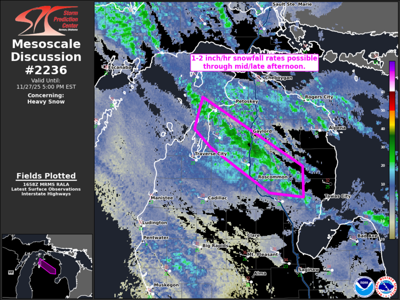
Areas affected...Northern Lower Michigan
Concerning...Heavy snow
Valid 271700Z - 272200Z
SUMMARY...Snowfall rates of 1-2 inch per hour remain possible
through mid/late afternoon.
DISCUSSION...A dominant snow band off of Lake Michigan, with
upstream connection to Lake Superior, continues early this afternoon
in northern Lower Michigan. Dual-pol data from KAPX shows higher KDP
values within this band suggesting 1-2 inch per hour snowfall rates
are possible. Given limited change in the large-scale environment
over the next few hours, this band is expected to persist through
the afternoon. High-resolution ensemble guidance suggests this as
well. The most intense snowfall rates will likely being to wane by
late afternoon as mid-level ascent from a shortwave trough moves
away from the region. As this occurs, there may be a slight
southward wobble in the band as 850-700 mb winds subtly take on a
more northerly component.
..Wendt.. 11/27/2025
...Please see www.spc.noaa.gov for graphic product...
ATTN...WFO...APX...
LAT...LON 44358438 44878534 45088560 45208556 45458547 44668384
44298383 44358438
|
|
|
Top/All Mesoscale Discussions/Forecast Products/Home |
|
Source link