| Mesoscale Discussion 2227 | |
| < Previous MD | |
|
|
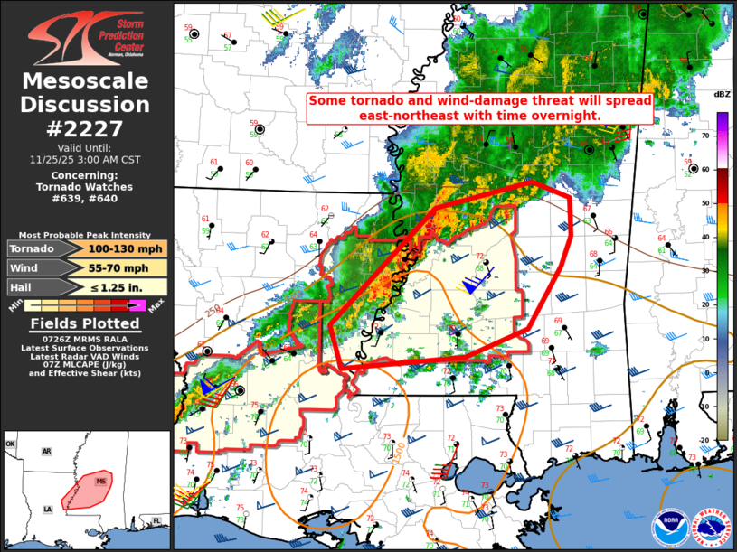
Mesoscale Discussion 2227 NWS Storm Prediction Center Norman OK 0128 AM CST Tue Nov 25 2025 Areas affected...Northeast LA into central/southern MS Concerning...Tornado Watch 639...640... Valid 250728Z - 250900Z The severe weather threat for Tornado Watch 639, 640 continues. SUMMARY...Some tornado and wind-damage threat will spread east-northeast with time overnight. DISCUSSION...A large southwest to northwest oriented storm cluster is ongoing early this morning from LA into central/northern MS. A midlevel shortwave trough currently near the ArkLaTex region, and an associated strong low-level jet, will sustain this convection overnight as it moves east-northeastward through a moist and modestly unstable environment. Strong deep-layer shear (generally 50-60 kt) will continue to sustain organized convection with a threat of wind damage, while enlarged hodographs (with 0-1 km SRH of greater than 300 m2/s2 per the KDGX VWP) will support some tornado potential with any persistent supercell structures or line-embedded circulations. A tendency for the composite outflow to sag southeastward may continue to temper the severe threat to some extent. However, the strong low-level jet will aid in the northeastward expansion of richer boundary-layer moisture and modest surface-based buoyancy with time. A potentially severe line segment currently approaching the LA/MS border will likely persist as it moves near and south of the outflow-reinforced baroclinic zone. Farther north/east, marginal supercells currently north of Jackson, MS (as of 0725 UTC) could pose a tornado and isolated wind-damage threat, if they remain in the effective warm sector. Some severe threat will eventually spread east/northeast of WW 640, which could eventually necessitate local watch expansion or new watch issuance. ..Dean/Hart.. 11/25/2025 ...Please see www.spc.noaa.gov for graphic product... ATTN...WFO...JAN...LIX... LAT...LON 31689188 32869066 33128953 32958908 32588908 32288919 31658959 31389031 31259175 31689188 MOST PROBABLE PEAK TORNADO INTENSITY...100-130 MPH MOST PROBABLE PEAK WIND GUST...55-70 MPH MOST PROBABLE PEAK HAIL SIZE...UP TO 1.25 IN |
|
|
Top/All Mesoscale Discussions/Forecast Products/Home |
|
Source link