| Mesoscale Discussion 221 | |
| < Previous MD Next MD > | |

|
|
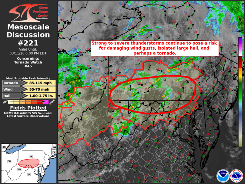
Mesoscale Discussion 0221 NWS Storm Prediction Center Norman OK 0334 PM CDT Wed Mar 11 2026 Areas affected...portions of southern Pennsylvania...northeastern West Virginia...and northern Maryland Concerning...Tornado Watch 45... Valid 112034Z - 112200Z The severe weather threat for Tornado Watch 45 continues. SUMMARY...Strong to severe thunderstorms continue to pose a risk for damaging wind gusts, isolated large hail, and perhaps a tornado across Tornado Watch 45. Tornado Watch 45 has been extended eastward to cover the continuing severe risk, but a downstream watch appears unlikely at this time. DISCUSSION...Several low-topped supercells ongoing across portions of eastern Ohio into central Pennsylvania have produced sporadic damaging wind gusts and large hail over the past 1-2 hours and have occasionally shown signs of stronger low-level rotation. While buoyancy remains rather limited along this corridor (250-500 J/kg MLCAPE per latest RAP-based mesoanalysis) owing to weak mid-level lapse rates, strong low-level and deep-layer shear will continue to support an isolated severe risk for the next 1-2 hours. In the short term, a localized zone of marginally increased severe potential may exist across portions of south-central Pennsylvania, including the Juniata River Valley, where latest mesoanalysis suggests available buoyancy may be a bit higher (locally up to 1000 J/kg MLCAPE). Owing to recent observations, Tornado Watch 45 has been locally extended eastward to cover the continuing severe risk. However, a downstream watch appears unlikely at this time owing to increasing convective inhibition and more well-mixed boundary layer profiles with eastward extent. ..Chalmers/Gleason.. 03/11/2026 ...Please see www.spc.noaa.gov for graphic product... ATTN...WFO...PHI...CTP...LWX...PBZ... LAT...LON 39538020 39788044 40088035 40377992 40517930 40587857 40667763 40667703 40607654 40497628 40357614 40197616 39967619 39607649 39447688 39287737 39237804 39227861 39307917 39407968 39538020 MOST PROBABLE PEAK TORNADO INTENSITY...85-115 MPH MOST PROBABLE PEAK WIND GUST...55-70 MPH MOST PROBABLE PEAK HAIL SIZE...1.00-1.75 IN |
|
|
Top/All Mesoscale Discussions/Forecast Products/Home |
|
Source link