| Mesoscale Discussion 220 | |
| < Previous MD | |

|
|
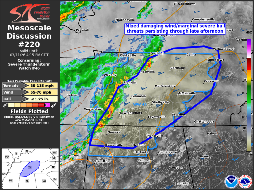
Mesoscale Discussion 0220 NWS Storm Prediction Center Norman OK 0222 PM CDT Wed Mar 11 2026 Areas affected...middle TN and far northern AL Concerning...Severe Thunderstorm Watch 46... Valid 111922Z - 112115Z The severe weather threat for Severe Thunderstorm Watch 46 continues. SUMMARY...Mixed damaging wind/marginal severe hail threats should persist through late afternoon across mainly middle Tennessee into far northern Alabama. DISCUSSION...A couple of embedded supercells within a broken QLCS have yielded marginal severe hail and downed tree reports thus far. The boundary layer remains warm ahead of this activity, with surface temps mainly in the upper 70s to lower 80s. This will sustain a mixed damaging wind/severe hail threat over the next 2-3 hours. 18Z BNA sounding and recent VWP data confirm a nearly unidirectional southwesterly low-level wind profile with modest speed shear. This could support a brief tornado or two, but should largely remain a secondary hazard. Convection bubbling on the trailing portion of the outflow along the MS/AL border could yield an uptick in severe potential across far northern AL. ..Grams/Gleason.. 03/11/2026 ...Please see www.spc.noaa.gov for graphic product... ATTN...WFO...MRX...JKL...LMK...OHX...HUN... LAT...LON 36518653 36748584 36778499 36698461 36348453 35708483 34918612 34488696 34558812 34938801 35428761 35858737 36138686 36518653 MOST PROBABLE PEAK TORNADO INTENSITY...85-115 MPH MOST PROBABLE PEAK WIND GUST...55-70 MPH MOST PROBABLE PEAK HAIL SIZE...UP TO 1.25 IN |
|
|
Top/All Mesoscale Discussions/Forecast Products/Home |
|
Source link