|
|
| Mesoscale Discussion 2198 | |

|
|
   Mesoscale Discussion 2198
   NWS Storm Prediction Center Norman OK
   0300 PM CST Fri Nov 07 2025

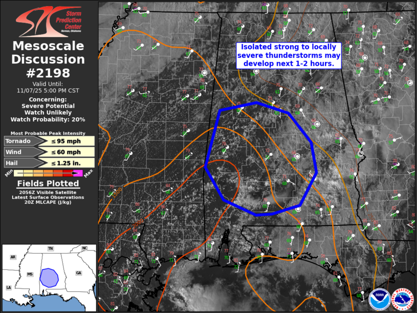
   Areas affected...portions of central/southern Alabama

   Concerning...Severe potential...Watch unlikely

   Valid 072100Z - 072300Z

   Probability of Watch Issuance...20 percent

   SUMMARY...Isolated strong to locally severe thunderstorms may
   develop over the next couple of hours across parts of central and
   southern Alabama. Strong gusts, and perhaps a brief tornado will be
   the main hazards with any more intense cells that can develop.

   DISCUSSION...Deepening updrafts have occasionally been noted in
   visible satellite imagery and via KMOB radar over the past hour.
   Convective development is trying to occur in the wake of earlier day
   shower/cloudiness and within a low-level warm advection regime. Weak
   low-level convergence is also noted in surface observations. Surface
   heating into the 70s and dewpoints climbing into the mid 60s F are
   supporting a narrow corridor of moderate instability across
   southwest AL.

   Large-scale ascent will remain nebulous across the area, with any
   stronger forcing remaining focused further north toward TN. As a
   result, storm development and coverage are uncertain. Given
   favorable deep shear across the region and sufficient instability,
   if an updraft can become sustained, an organized cell can not be
   ruled out. Any stronger convection could produce locally gusty
   winds, small hail, or perhaps a brief spin-up. Given uncertainty, a
   watch is not currently expected, but trends will be monitored.

   ..Leitman/Smith.. 11/07/2025

   ...Please see www.spc.noaa.gov for graphic product...

   ATTN...WFO...BMX...MOB...

   LAT...LON   32088842 33168811 33308730 33108658 32558608 31998597
               31388635 31218696 31208730 31478801 32088842

   MOST PROBABLE PEAK TORNADO INTENSITY...UP TO 95 MPH
   MOST PROBABLE PEAK WIND GUST...UP TO 60 MPH
   MOST PROBABLE PEAK HAIL SIZE...UP TO 1.25 IN
|
|
|
Top/All Mesoscale Discussions/Forecast Products/Home |
|
Source link


