|
|
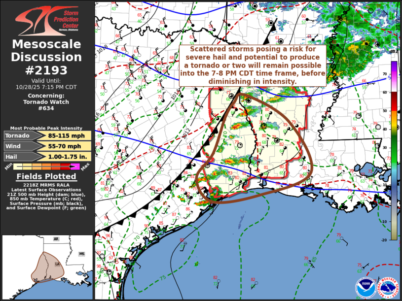
| Mesoscale Discussion 2193 | |

|
|
Mesoscale Discussion 2193 NWS Storm Prediction Center Norman OK 0521 PM CDT Tue Oct 28 2025 Areas affected...parts of southeastern Texas into central and southwestern Louisiana Concerning...Tornado Watch 634... Valid 282221Z - 290015Z The severe weather threat for Tornado Watch 634 continues. SUMMARY...Scattered strong thunderstorms, including a couple of supercells posing risk for severe hail and potential to produce a tornado or two, will continue developing southeastward across the region through 7-8 PM CDT, before diminishing. DISCUSSION...The southeastward advancing cold front appears to be rapidly overtaking the preceding narrow corridor of stronger instability across the mid/upper Texas coastal plain into the Texas Piney Woods. However, model output suggests that boundary-layer moisture advection and southeastward spreading mid/upper forcing for ascent will support sufficient destabilization to maintain vigorous thunderstorm activity east-southeastward into and through much of southwestern and portions of central Louisiana during the next few hours. This is likely to include continuing generally discrete thunderstorm activity. Low-level hodographs are still rather modest to weak, but strong deep-layer shear is more than sufficient for supercells posing a risk for severe hail, with at least some potential to produce a tornado or two into the 00-01Z time frame. ..Kerr.. 10/28/2025 ...Please see www.spc.noaa.gov for graphic product... ATTN...WFO...LCH...SHV...HGX... LAT...LON 32229389 31519254 30179188 29589343 29409485 30019533 30669483 31659447 32039419 32229389 MOST PROBABLE PEAK TORNADO INTENSITY...85-115 MPH MOST PROBABLE PEAK WIND GUST...55-70 MPH MOST PROBABLE PEAK HAIL SIZE...1.00-1.75 IN |
|
|
Top/All Mesoscale Discussions/Forecast Products/Home |
|
Source link