|
|
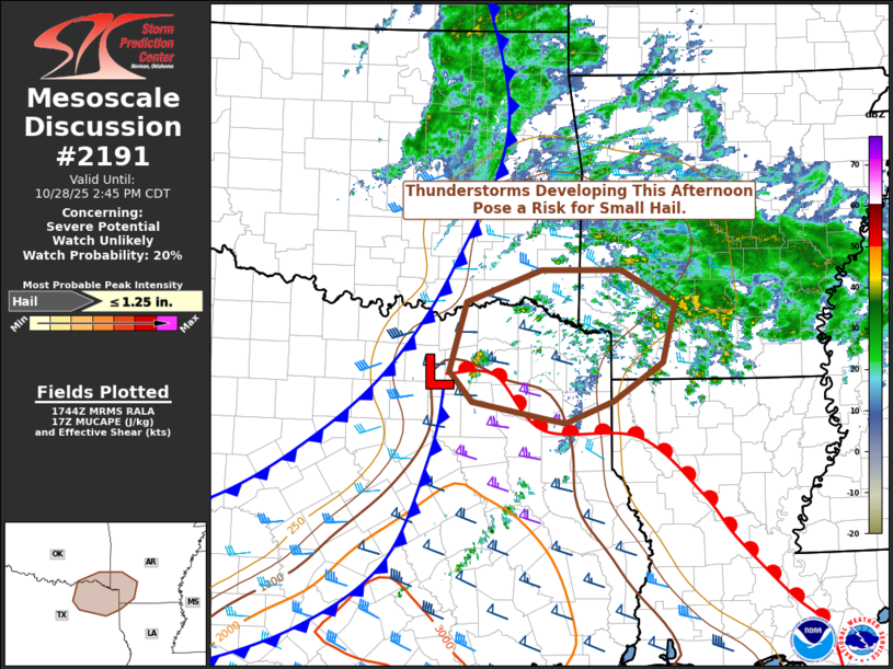
| Mesoscale Discussion 2191 | |
|
|
   Mesoscale Discussion 2191
   NWS Storm Prediction Center Norman OK
   1246 PM CDT Tue Oct 28 2025

   Areas affected...northeast Texas...far southeast Oklahoma...and
   southwest Arkansas

   Concerning...Severe potential...Watch unlikely

   Valid 281746Z - 281945Z

   Probability of Watch Issuance...20 percent

   SUMMARY...The thunderstorm threat should increase over the next
   couple of hours. The overall environment will support a risk of
   small hail. A watch is not currently expected.

   DISCUSSION...Thunderstorms are expected to develop in the next 1-2
   hours across portions of northeast Texas and southeast Oklahoma as
   large-scale ascent continues to increase. This region is located
   beneath the right-exit region of 120-knot upper-level jet
   (subsident) but also  in a zone of increasing/yet modest warm-air
   advection near 700-millibars owing to isentropic flow across a
   surface warm front across east Texas. Additional forcing for ascent
   will come from a seasonably strong surface cold front surging
   southeast across the region.

   Forecast soundings to the north of this warm front suggest elevated
   instability on the order of 500-1000 J/kg and long hodographs will
   be available to any thunderstorm that develops. Thus, despite only
   modest mid-level lapse rates, the degree of instability and
   strengthening kinematic fields will support the potential of small
   hail. Gusty winds associated with the cold front passage will also
   be possible.

   Given the limited nature of any potential severe risk, a watch is
   not anticipated across this area.

   ..Marsh/Bunting.. 10/28/2025

   ...Please see www.spc.noaa.gov for graphic product...

   ATTN...WFO...LZK...SHV...TSA...FWD...OUN...

   LAT...LON   33109623 33909601 34279498 34269390 33869317 33209333
               32779400 32529466 32569489 32759593 33109623

   MOST PROBABLE PEAK HAIL SIZE...UP TO 1.25 IN
|
|
|
Top/All Mesoscale Discussions/Forecast Products/Home |
|
Source link