|
|
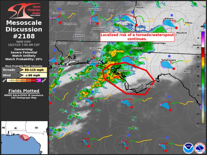
| Mesoscale Discussion 2188 | |

|
|
   Mesoscale Discussion 2188
   NWS Storm Prediction Center Norman OK
   0527 AM CDT Mon Oct 27 2025

   Areas affected...Coastal portions of the central Florida Panhandle

   Concerning...Severe potential...Watch unlikely

   Valid 271027Z - 271200Z

   Probability of Watch Issuance...20 percent

   SUMMARY...A localized risk of a tornado or two and waterspouts
   continues over coastal portions of the central Florida Panhandle.
   Given the localized nature of the risk, the need for a watch is
   uncertain, though trends are being monitored closely.

   DISCUSSION...After several storm mergers, a well-established
   supercell has evolved about 13 miles offshore of the Panama City
   coast area. Radar data over the last 30 minutes, coupled with
   forecaster experience, suggest high confidence that two waterspouts
   have occurred with this supercell. The storm is focused within a
   persistent north/south-oriented low-level confluence zone and is
   being aided by 150-200 m2/s2 0-1 km SRH (per EVX/TLH VWP data).
   While the severe risk associated with this activity may remain
   offshore where boundary-layer moisture/heat fluxes are aiding in its
   current intensity, lower 70s dewpoints along the immediate coastal
   areas of the central FL Panhandle do support some risk of inland
   progression. If this were to occur, a tornado or two could not be
   ruled out -- given the well-established low-level mesocylone. Given
   the spatially confined area and considerable uncertainty of a
   tornado risk developing onshore, the need for a watch is uncertain.

   ..Weinman/Smith.. 10/27/2025

   ...Please see www.spc.noaa.gov for graphic product...

   ATTN...WFO...TAE...

   LAT...LON   29578538 29988606 30208610 30368587 30428540 30208474
               29908449 29538477 29578538

   MOST PROBABLE PEAK TORNADO INTENSITY...85-115 MPH
   MOST PROBABLE PEAK WIND GUST...UP TO 60 MPH
|
|
|
Top/All Mesoscale Discussions/Forecast Products/Home |
|
Source link