|
|
| Mesoscale Discussion 2180 | |

|
|
   Mesoscale Discussion 2180
   NWS Storm Prediction Center Norman OK
   0346 PM CDT Sat Oct 25 2025

   Areas affected...portions of far northeast Oregon into far southeast
   Washington and western Idaho

   Concerning...Severe potential...Watch unlikely

   Valid 252046Z - 252215Z

   Probability of Watch Issuance...5 percent

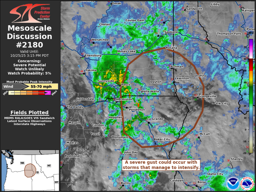
   SUMMARY...A severe gust or two may occur with one of the stronger
   storms that can develop over the next few hours.

   DISCUSSION...Visible satellite, MRMS mosaic radar imagery, and NLDN
   lightning data all show the development and possible intensification
   of low-topped convection across portions of the Pacific Northwest
   into the northern Rockies. Here, modest diurnal heating beneath cold
   temperatures aloft is supporting scant buoyancy with boundary-layer
   destabilization. An 80+ kt 500 mb jet streak is beginning to pivot
   around the upper trough, and is poised to overspread the region in
   the next few hours (as shown by 20Z mesoanalysis). This will further
   increase vertical speed shear and provide a stronger wind field
   aloft for severe gusts, should effective downward momentum transport
   be realized. The current thinking is that the newly developed storms
   will oscillate in intensity. However, if a storm or two could
   sufficiently deepen, a couple of severe convective gusts are not out
   of the question over the next few hours.

   ..Squitieri/Gleason.. 10/25/2025

   ...Please see www.spc.noaa.gov for graphic product...

   ATTN...WFO...MSO...BOI...OTX...PDT...

   LAT...LON   45001894 46161910 46831880 47151825 47291740 47141682
               46801624 46251588 45581594 45131628 44851673 44661741
               44611824 45001894

   MOST PROBABLE PEAK WIND GUST...55-70 MPH
|
|
|
Top/All Mesoscale Discussions/Forecast Products/Home |
|
Source link


