|
|
| Mesoscale Discussion 2179 | |

|
|
   Mesoscale Discussion 2179
   NWS Storm Prediction Center Norman OK
   0253 PM CDT Sat Oct 25 2025

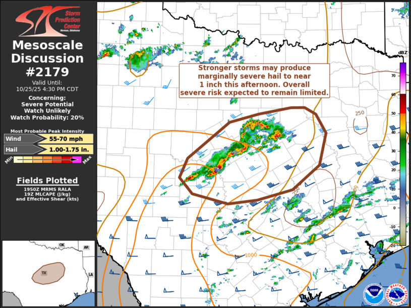
   Areas affected...portions of north-central TX

   Concerning...Severe potential...Watch unlikely

   Valid 251953Z - 252130Z

   Probability of Watch Issuance...20 percent

   SUMMARY...Isolated strong storms may produce marginally severe hail
   and gusty winds this afternoon.

   DISCUSSION...Isolated strong storms have developed this afternoon
   near a cold front draped across central into north Texas. This
   activity is developing beneath the colder core of the midlevel
   trough and on the fringes of the stronger midlevel jet. MLCAPE
   ranges from around 500-1500 J/kg where storms have developed, but
   the downstream airmass remains capped. Weaker instability is also
   downstream, where overnight/early morning convection resulted in
   overturning. Airmass recovery has been slow, limited by early cloud
   cover and veered low-level winds.

   While this may limit overall severe potential, cool temperatures
   aloft and greater than 40 kt effective shear magnitudes could
   support transient strong updrafts with a potential for marginal hail
   and gusty winds with the strongest cells this afternoon.

   ..Leitman/Gleason.. 10/25/2025

   ...Please see www.spc.noaa.gov for graphic product...

   ATTN...WFO...FWD...EWX...SJT...

   LAT...LON   31119949 31519930 32269830 32439761 32569682 32569648
               32429621 32029597 31369615 30879679 30669764 30589833
               30779919 30899929 31119949

   MOST PROBABLE PEAK WIND GUST...55-70 MPH
   MOST PROBABLE PEAK HAIL SIZE...1.00-1.75 IN
|
|
|
Top/All Mesoscale Discussions/Forecast Products/Home |
|
Source link


