|
|
| Mesoscale Discussion 2176 | |

|
|
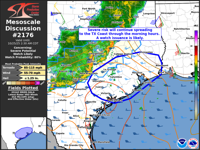
   Mesoscale Discussion 2176
   NWS Storm Prediction Center Norman OK
   1256 AM CDT Sat Oct 25 2025

   Areas affected...Parts of Southeast Texas

   Concerning...Severe potential...Watch likely

   Valid 250556Z - 250730Z

   Probability of Watch Issuance...80 percent

   SUMMARY...The severe risk will continue spreading east-southeastward
   to the Texas Coast through the early morning hours. Damaging winds
   gusts are the main concern, though a brief/embedded tornado cannot
   be ruled out.

   DISCUSSION...The latest radar data from KEWX shows an MCS tracking
   east-southeastward at around 40 kt across parts of south-central TX.
   While the leading-line updrafts have decreased in intensity over the
   last hour or so, the well-established cold pool and moist
   pre-convective air mass continues to support embedded damaging wind
   gusts -- especially with any embedded mesovortex structures (i.e.,
   north/south-oriented portions of the line) in the near term.

   With time, the MCS will continue tracking east-southeastward to the
   TX Coast through the early morning hours. Around 40 kt of
   line-orthogonal effective shear and a moist/moderately unstable
   downstream air mass will continue to support a risk of damaging wind
   gusts and perhaps a brief/embedded tornado risk -- aided by a
   modest/gradually strengthening low-level jet and related low-level
   hodograph curvature. A watch will likely be issued within the hour
   for parts of the area.

   ..Weinman/Smith.. 10/25/2025

   ...Please see www.spc.noaa.gov for graphic product...

   ATTN...WFO...LCH...HGX...CRP...EWX...

   LAT...LON   29359768 29879737 30559618 30809487 30649392 30279375
               29749378 28649542 28439625 28609691 28889744 29359768

   MOST PROBABLE PEAK TORNADO INTENSITY...85-115 MPH
   MOST PROBABLE PEAK WIND GUST...55-70 MPH
   MOST PROBABLE PEAK HAIL SIZE...UP TO 1.25 IN
|
|
|
Top/All Mesoscale Discussions/Forecast Products/Home |
|
Source link