|
|
| Mesoscale Discussion 2173 | |

|
|
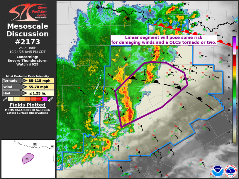
Mesoscale Discussion 2173 NWS Storm Prediction Center Norman OK 0711 PM CDT Fri Oct 24 2025 Areas affected...DFW Vicinity Concerning...Severe Thunderstorm Watch 629... Valid 250011Z - 250145Z The severe weather threat for Severe Thunderstorm Watch 629 continues. SUMMARY...A linear segment of storms will pose some risk for damaging/severe winds as well as a brief QLCS tornado or two into mid evening. DISCUSSION...A linear segment is moving into parts of North Texas this evening. This feature produced a 51 kt wind gust in Brownwood. Though temperatures south of the differential heating boundary have cooled a degree or two over the last hour, low 80s F inflow remains. Given the more unstable inflow than storm to the north and modest increase in 850 mb winds, it is likely this activity continues over the next couple of hours and approaches the DFW metro. The KFWS VAD continues to show enlarged low-level hodographs as well as an improving mid-level wind profile. Damaging/severe gusts as well as QLCS circulations/tornadoes will be possible into mid evening. ..Wendt.. 10/25/2025 ...Please see www.spc.noaa.gov for graphic product... ATTN...WFO...FWD... LAT...LON 31649865 32429880 33019807 33059791 33029750 32819704 32549697 32069762 31649865 MOST PROBABLE PEAK TORNADO INTENSITY...85-115 MPH MOST PROBABLE PEAK WIND GUST...55-70 MPH MOST PROBABLE PEAK HAIL SIZE...UP TO 1.25 IN |
|
|
Top/All Mesoscale Discussions/Forecast Products/Home |
|
Source link


