|
|
| Mesoscale Discussion 2171 | |

|
|
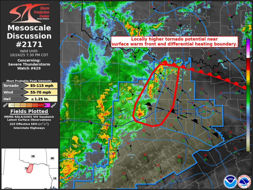
Mesoscale Discussion 2171 NWS Storm Prediction Center Norman OK 0600 PM CDT Fri Oct 24 2025 Areas affected...North Texas Concerning...Severe Thunderstorm Watch 629... Valid 242300Z - 250030Z The severe weather threat for Severe Thunderstorm Watch 629 continues. SUMMARY...A locally greater tornado threat is evident near two surface boundaries in North Texas. DISCUSSION...Surface observations show a warm front near the Red River and a differential heating boundary farther south, roughly east-west through the DFW metroplex. With a continued increase in mid-level ascent, a few storms have been able to intensify ahead of a large area of stratiform rain in the Rolling Plains. The storm in Palo Pinto County has shown the most organization and modest low-level rotation over the last 30 minutes. The KFWS VAD does show amply low-level hodograph curvature near the differential heating zone. As long as storms remain discrete, there will be a locally higher tornado potential near these surface boundaries. ..Wendt.. 10/24/2025 ...Please see www.spc.noaa.gov for graphic product... ATTN...WFO...FWD...OUN... LAT...LON 32489847 32629853 32899846 33639798 33819778 33789742 33739727 33459730 32829744 32659757 32409777 32379801 32489847 MOST PROBABLE PEAK TORNADO INTENSITY...85-115 MPH MOST PROBABLE PEAK WIND GUST...55-70 MPH MOST PROBABLE PEAK HAIL SIZE...UP TO 1.25 IN |
|
|
Top/All Mesoscale Discussions/Forecast Products/Home |
|
Source link