|
|
| Mesoscale Discussion 2165 | |

|
|
Mesoscale Discussion 2165
NWS Storm Prediction Center Norman OK
0639 PM CDT Thu Oct 23 2025
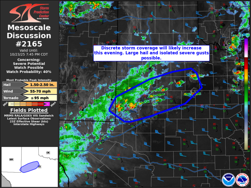
Areas affected...Permian Basin into Texas South Plains
Concerning...Severe potential...Watch possible
Valid 232339Z - 240045Z
Probability of Watch Issuance...40 percent
SUMMARY...Large to conditionally very-large hail and isolated severe
gusts will be the main hazards with scattered storms this evening. A
severe thunderstorm watch is possible depending on convective
intensity trends.
DISCUSSION...Regional radar imagery is showing the initial stages of
discrete storm development within parts of the Permian Basin into
the Texas South Plains. A band of cirrus within the southern Plains
is indicative of lift associated with an upper trough that will be
digging into the region over the next several hours. That cloud
cover has limited surface based instability, though greater MLCAPE
is noted farther east into the Rolling Plains. Strong mid-level
winds are promoting 45-55 kts of 0-6 km shear. At least some storm
organization can be expected. Large to potentially very large hail
could occur as mid-level lapse rates are rather steep (per 18Z MAF
sounding). Dry low levels will tend to mitigate some storm
intensity, however. Isolated severe wind gusts are also possible. A
brief tornado could also occur given southeasterly surface winds and
an increasing low-level jet this evening. A severe thunderstorm
watch is possible this evening. Storm intensity is somewhat
uncertain, but coverage may be scattered. The overall scenario may
be that a few more intense storms develop, but storm interaction
keeps the duration of these storms limited. Trends will be
monitored.
..Wendt/Hart.. 10/23/2025
...Please see www.spc.noaa.gov for graphic product...
ATTN...WFO...SJT...LUB...MAF...
LAT...LON 32320328 32390329 32760306 33320183 33540097 33640029
33510008 33049989 32550052 32160179 31990249 31990272
32320328
MOST PROBABLE PEAK TORNADO INTENSITY...UP TO 95 MPH
MOST PROBABLE PEAK WIND GUST...55-70 MPH
MOST PROBABLE PEAK HAIL SIZE...1.50-2.50 IN
|
|
|
Top/All Mesoscale Discussions/Forecast Products/Home |
|
Source link