|
|
| Mesoscale Discussion 2163 | |

|
|
   Mesoscale Discussion 2163
   NWS Storm Prediction Center Norman OK
   0203 PM CDT Thu Oct 23 2025

   Areas affected...The Four Corners region into northern New Mexico
   and southern Colorado

   Concerning...Severe potential...Watch unlikely

   Valid 231903Z - 232100Z

   Probability of Watch Issuance...5 percent

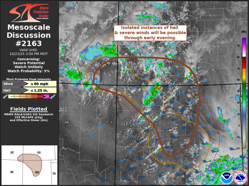
   SUMMARY...Instances of isolated hail and severe winds will be
   possible as thunderstorms continue to develop through early evening.
   Watch issuance is not expected given the modest convective
   environment.

   DISCUSSION...Over the past hour, a slight uptick in convective
   intensity has been noted across the Four Corners and northern NM in
   GOES imagery and MRMS vertically integrated ice data. This
   intensification is likely the result of steadily increasing MLCAPE
   as temperatures warm into the low/mid 60s under a pocket of cold
   temperatures aloft (-15 to -20 C at around 500 mb). Further heating
   through the late afternoon will promote additional convective
   development and the potential further intensification of ongoing
   storms, though very limited moisture will modulate overall buoyancy
   values with MLCAPE expected to peak at around 500-750 J/kg. Despite
   marginal buoyancy, 40-50 knot mid-level flow has recently been
   sampled by regional VWPs ahead of the vorticity maximum, which
   should provide adequate shear through the CAPE-bearing layer for
   somewhat organized/persistent convection with an accompanying threat
   for hail (most likely between 0.5 to 1.25 inches in diameter).
   Low-level lapse rates have increased to around 8 C/km where surface
   heating has been strongest (primarily over north-central NM), which
   may support a few stronger wind gusts with the more intense
   convective cores through late afternoon. While a few instances of
   hail/severe winds are possible, the modest thermodynamic environment
   should act to limit the coverage of strong/severe storms.

   ..Moore/Mosier.. 10/23/2025

   ...Please see www.spc.noaa.gov for graphic product...

   ATTN...WFO...PUB...ABQ...GJT...FGZ...SLC...

   LAT...LON   38080923 38110852 38110736 38060662 37900591 37660546
               37300516 36720499 36160503 35410515 34650556 34270609
               34210647 34340673 35150708 35460721 35630750 36550868
               36770948 36850989 37051021 37451016 37810978 38080923

   MOST PROBABLE PEAK WIND GUST...UP TO 60 MPH
   MOST PROBABLE PEAK HAIL SIZE...UP TO 1.25 IN
|
|
|
Top/All Mesoscale Discussions/Forecast Products/Home |
|
Source link


