| Mesoscale Discussion 213 | |
| < Previous MD | |

|
|
Mesoscale Discussion 0213
NWS Storm Prediction Center Norman OK
0910 AM CDT Wed Mar 11 2026
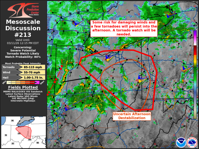
Areas affected...Upper Ohio Valley
Concerning...Severe potential...Tornado Watch likely
Valid 111410Z - 111615Z
Probability of Watch Issuance...80 percent
SUMMARY...While surface-based instability may remain limited, strong
low-level flow will promote damaging wind and tornado potential into
the afternoon. A tornado watch is likely.
DISCUSSION...A narrow band of convection continues to race eastward
into western Ohio this morning. The KIND and KILN VWP showed around
75 kts in the lowest 2 km. Despite limited buoyancy, convection
should be deep enough to promote damaging wind potential based on
the strength of the low-level flow alone. Furthermore, VWP data from
regional 88D/TDWR also showed enlarged low-level hodographs. A few
tornadoes will be possible within the line of convection as it
continues into the afternoon. The main question going forward will
be the degree of destabilization downstream of the current strongest
activity. A broad area of precipitation precedes the narrow band and
is moving from southern Ohio into western Pennsylvania. Buoyancy may
continue to remain limited as a result. The low-level moisture
content is sufficient enough that even weak surface heating would
allow for stronger convection. There is also some potential for
additional activity to form on the southern flank of the
precipitation later this afternoon. Though these uncertainties
exist, the environment will still support damaging wind and tornado
potential. A tornado watch will likely be needed.
..Wendt/Gleason.. 03/11/2026
...Please see www.spc.noaa.gov for graphic product...
ATTN...WFO...PBZ...RLX...CLE...ILN...
LAT...LON 40258245 40828330 41058362 41268353 41548243 41588146
41578091 41338003 40737976 40177988 39327999 39318087
39598150 40258245
MOST PROBABLE PEAK TORNADO INTENSITY...85-115 MPH
MOST PROBABLE PEAK WIND GUST...55-70 MPH
MOST PROBABLE PEAK HAIL SIZE...1.00-1.75 IN
|
|
|
Top/All Mesoscale Discussions/Forecast Products/Home |
|
Source link