

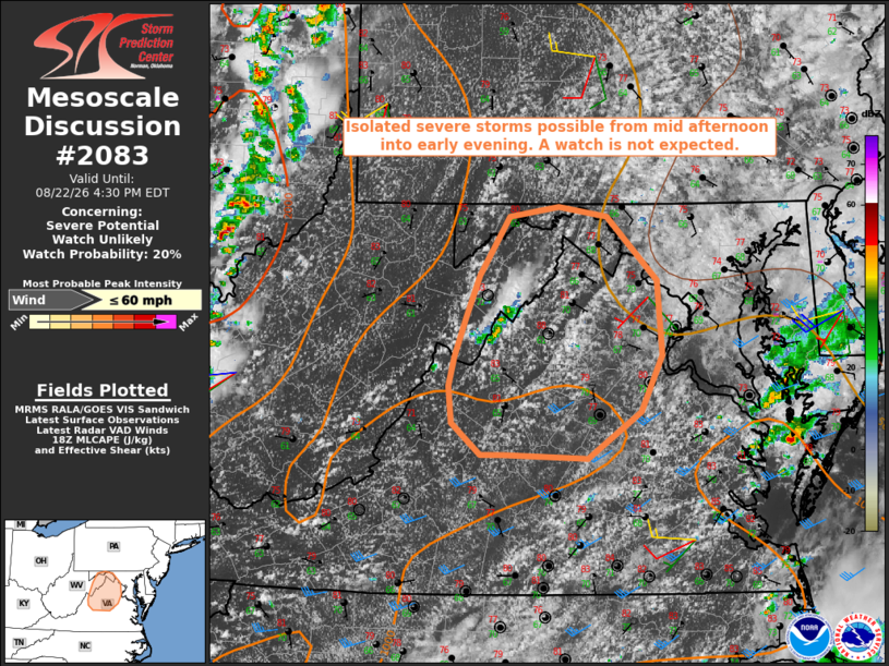
| Mesoscale Discussion 2083 | |
| < Previous MD | |

|
|
   Mesoscale Discussion 2083
   NWS Storm Prediction Center Norman OK
   0127 PM CDT Sat Aug 22 2026

   Areas affected...West Virginia and Maryland Panhandles into northern
   and central Virginia

   Concerning...Severe potential...Watch unlikely

   Valid 221827Z - 222030Z

   Probability of Watch Issuance...20 percent

   SUMMARY...Isolated severe storms appear possible from mid-afternoon
   into this evening. Damaging wind gusts are the primary hazard. A
   watch issuance is not anticipated due to the limited areal coverage
   of the threat.

   DISCUSSION...Recent thunderstorm development has occurred over the
   WV Panhandle, northwest of Harrisonburg, VA, amidst a moist and
   moderately unstable air mass with MLCAPE of 1500-2000 J/kg. Farther
   east along the lee side of the Blue Ridge, visible satellite imagery
   indicates deepening cumulus within a low-level upslope regime.
   Latest time-lagged HRRR and RRFS ensemble guidance suggests that a
   small cluster of thunderstorms may evolve out of those areas of
   deepening moist convection over northern VA later this afternoon
   into evening.

   The current VWP from Charleston, WV is sampling 30-40 kt of westerly
   winds above 4 km AGL, which may contribute to some organization as
   updrafts continue to mature this afternoon. When coupled with
   steepening low-level lapse rates, the environment appears supportive
   of locally damaging wind gusts as storms progress east across the
   discussion area.

   ..Mead/Smith.. 08/22/2026

   ...Please see www.spc.noaa.gov for graphic product...

   ATTN...WFO...AKQ...LWX...RNK...

   LAT...LON   38487947 38807935 39137920 39617890 39707838 39617788
               39107736 38497732 38027754 37647808 37677895 37687919
               37937950 38247953 38487947

   MOST PROBABLE PEAK WIND GUST...UP TO 60 MPH
|
|
|
Top/All Mesoscale Discussions/Forecast Products/Home |
|
Source link