|
|
| Mesoscale Discussion 2021 | |
| < Previous MD | |

|
|
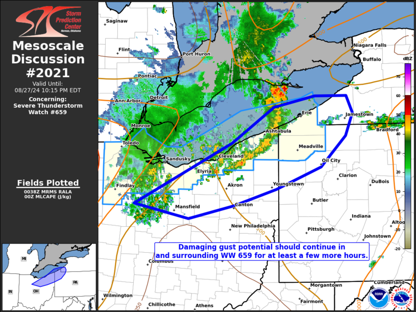
Mesoscale Discussion 2021 NWS Storm Prediction Center Norman OK 0739 PM CDT Tue Aug 27 2024 Areas affected...portions of far northern Ohio into extreme northwestern Pennsylvania and extreme southwestern New York Concerning...Severe Thunderstorm Watch 659... Valid 280039Z - 280215Z The severe weather threat for Severe Thunderstorm Watch 659 continues. SUMMARY...Some severe threat will persist for a few more hours in and immediately surrounding Severe Thunderstorm Watch 659. Damaging gusts remain the primary concern. DISCUSSION...A pronounced cold pool, originating from a mature persistent elongated convective system, has surged southeastward across Lake Erie over the past couple of hours. At least a few severe gusts have been observed, and some convective rejuvenation has occurred along the cold pool leading edge. Buoyancy decreases/MLCINH increases with eastward and southward extent ahead of the ongoing storms/cold pool. However, the fast pace of the cold pool suggests that continued cellular regeneration and accompanying damaging wind gust potential will continue for at least a couple more hours. ..Squitieri.. 08/28/2024 ...Please see www.spc.noaa.gov for graphic product... ATTN...WFO...BUF...CTP...PBZ...CLE... LAT...LON 40858328 41748140 42268059 42427980 42427919 42177908 41847921 41387970 41068055 40838138 40638224 40858328 |
|
|
Top/All Mesoscale Discussions/Forecast Products/Home |
|


