| Mesoscale Discussion 20 | |
| < Previous MD | |

|
|
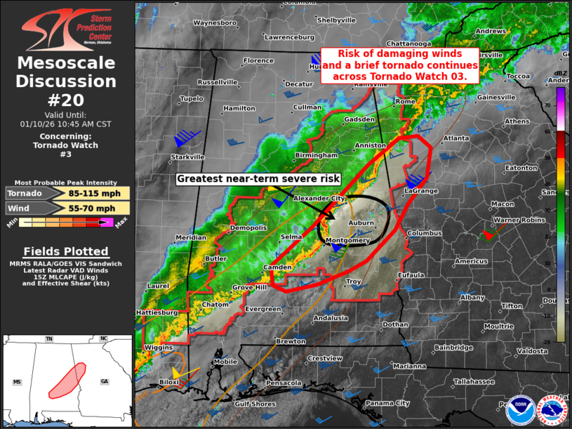
Mesoscale Discussion 0020 NWS Storm Prediction Center Norman OK 0921 AM CST Sat Jan 10 2026 Areas affected...Parts of southern/central AL into far western GA Concerning...Tornado Watch 3... Valid 101521Z - 101645Z The severe weather threat for Tornado Watch 3 continues. SUMMARY...The risk of damaging winds and a brief tornado continues across Tornado Watch 03 this morning. A downstream watch is not currently anticipated, though convective and environmental trends are being monitored. DISCUSSION...The latest radar data from KBMX/KMXX depicts a northeast/southwest-oriented QLCS tracking eastward across central and eastern AL. The primary severe risk associated with this activity should remain focused along north/south-oriented parts of the line (i.e., just west of the KMXX radar) -- where around 50 kt of line-orthogonal 0-6 km shear (per KMXX VWP) is favoring more intense updrafts keeping pace with the larger-scale cold pool. Here, moist inflow (upper 60s dewpoints) and ample low-level hodograph size/curvature (around 270 m2/s2 0-1 km SRH per KMXX VWP) will continue to support embedded mesovortex/supercell structures and an attendant risk for damaging gusts and a brief tornado or two. The northern portion of the QLCS moving into west-central GA is also taking on a more north/south orientation, and this area may also be locally favorable for damaging gusts and perhaps a brief tornado in the near term. However, as the QLCS approaches the eastern edge of Tornado Watch 03, buoyancy becomes quite limited, and current expectation is for convection to gradually weaken with northward and eastward extent. Therefore, a downstream watch is not currently expected, though convective and environmental trends are being monitored. ..Weinman/Smith.. 01/10/2026 ...Please see www.spc.noaa.gov for graphic product... ATTN...WFO...FFC...BMX...MOB... LAT...LON 32068715 32628648 33458558 33828509 33858478 33688457 33278464 32918495 32568515 32158561 32018590 31828639 31738690 31808710 32068715 MOST PROBABLE PEAK TORNADO INTENSITY...85-115 MPH MOST PROBABLE PEAK WIND GUST...55-70 MPH |
|
|
Top/All Mesoscale Discussions/Forecast Products/Home |
|
Source link